July 23.—1817
Extracts from oxley’s diary as he passed through Lake cargelligo. Extracts from his observations made in Guttenberg Press publication of his daily diaries as he came down and up the Lachlan. in 1817.

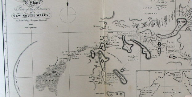
Oxleys map is a part sketch of the area bounded by the Northys Hills in the west and Sansons Hills in the east. The Lachlan River runs from the north-east to the west. Smalls Lake and Lake Cargelligo are circled in. Smalls Lake is Campbells Lake and Lake Cargelligo is Regents Lake. Northys Hills is the Goulburn Range. Mount Bing is Sansons Hills to the east of the Lachlan Range. Notice he has called all that area between “low marshy country”.
I’m posting this to reinforce the fact oh how depleted Lachlan Valley has become after colonisation.
Oxleys diary July 23, 1817 :
The river had fallen a little during the night. At nine o’clock we again set forward: the country became extremely low and marshy, far more so than any we had passed over east of Macquarie’s Range.(Lachlan) These marshes extended so far southerly that to have gone round them would have led us far from our purposed course without answering any useful purpose, and although we judged that at first they might not extend above three or four miles back, yet we soon had reason to change that opinion. The river had led us upon a general course nearly east about six miles, when about half a mile from the bank southerly, a very extensive lake was formed, extending about east-south-east and west-north-west from three to four miles, and being about a mile and a half wide. Excepting the sheet of water on the north side near the termination of the stream, this was the only one we had seen that could justly be entitled to the denomination of lake. We crossed over a low wet swamp, by which its overflowings are doubtless re-conveyed to the river. This lake was joined to another more easterly, but much smaller. We could not form any correct judgment how far the marshy ground extended south-east of it; but the country was low and level as far as Mount Byng, and a low range extended north-easterly from it. We now kept the banks of the stream, till at the tenth mile we ascended a small hill a mile south of it, from which Mount Byng(a hill somewhere between Lake Cargelligo and Tullibigeal) bore N. 12. E. Close under the hill ran a considerable branch of the river, which certainly supplied the lakes and lower grounds with water; on the other side of this arm, the country was low, and apparently marshy as far as we could see. On examination I found it would be extremely difficult to cross this branch, as the water was too shallow to swim the horses over, and the ground so soft that they could not approach the banks within several yards. I therefore determined to get upon the river nearly where this branch separated from it, and endeavour to construct a bridge, by which we might convey the provisions and baggage over: as to the horses, they could easily swim across.
The course of the river during the day had been nearly due east, but from the separation of the branch it seemed to take a more northerly direction; the banks were very low, and never exceeded five feet from the water. Occasional points of land somewhat more elevated than the general surface would of course make them in Places a little higher; but we could not discover any marks which denoted a greater rise than six feet, or six feet six inches, above the present level. When we halted in the evening, the stream was running with great rapidity. The water did not appear to have either risen or fallen during the day; but all the trees which would have best answered our purposes were now several feet in the water. We had however no alternative but to cross somewhere in this neighbourhood, as we were fearful of entangling ourselves in marshy ground by proceeding farther up this bank; and to attempt to penetrate, or even to round, the marshes to the southward, (if it were practicable,) would take up more time (without being of any service) than we could spare. Experience had made us too well acquainted with the nature of these marshes to run any needless risks; and we had besides great hopes that we should find better travelling to the northward, which as the river seemed inclined to come from that point would also be a great convenience to us, as I did not purpose to quit its banks as long as it continued to run any thing north of east.
As to the soil and general description of country passed over this day, the low-lands were all swamps covered with atriplex bushes, and where the land was a little more elevated, the soil was sandy and barren, covered with acacias, dodonaeae, small cypresses and dwarf box-trees. Our course was E. 4. N. 6¾ miles; but by the windings of the river, we had measured nearly 12 miles. The lake I named Campbell Lake (Smalls Lake), in honour of Mrs. Macquarie’s family name.

This Google Earth screenshot is the present day aerial view of the country Oxley is describing in his daily diaries of the 23rd and 24th of July 1817
July 24.—At day-light we attempted to construct our bridge near to the place where we were encamped, but as fast as the trees were felled they were swept away by the rapidity of the current; the breadth on an average being now, by reason of the flood, nearly sixty feet, and the trees on the immediate or proper banks being several feet in the water: we were therefore obliged to fell trees farther inland, and these, as before remarked, were swept away, falling short of the land on the opposite side.
All our attempts to construct a bridge during the day were fruitless, as the flood was too violent to allow the trees to take firm hold: in searching the banks of the stream for a proper place for our purpose, an arm nearly as large as the main branch up which we had travelled was discovered about a mile down the stream on the north side; it ran to the north-north-west, and then apparently trended more westerly. Thus is this vast body of water, all originating in the Eastern or Blue Mountains, conveyed over these extensive marshes, rendering uninhabitable a tract which they might reasonably be expected to fertilize.
Finding that in the present high state of the water we could not succeed in crossing the river, at least near our present station, and that if we returned lower down we should experience a farther difficulty in crossing the north-west arm recently seen, it was judged best to try if we could get over the branch on the south side, and swim the horses over in the main stream near the mouth of the branch. We could not, however, find any tree on this side that would reach across; although it was quite dark before we gave over the attempt for the night.
Oxley’s own map of his journey down the Lachlan 1817. The journey began at Cowra. He was blocked at Gemalong near Forbes on his way down. Was heading back to the sea in the south to hitch a ride back to Sydney. Turned around again near the present day Griffith went north to find Lachlan again. Proceeded down stream to Booligal then returned again past Lake Cargelligo. Crossed the river near Kiacatoo went back to the Macquarie and made his way back to Bathurst from there.
July 25.—Every means was again employed in constructing the bridge over the south-west branch. The stream had fallen but a few inches, and continues to fall too slowly to permit us to entertain any hopes of crossing it in this vicinity.
Our bridge was finished by one o’clock, but it being too late to cross the horses and baggage this evening, I went in company with Byrne on horseback to view the country to the southward. After going about two miles and a quarter south of the tent, we were most agreeably surprised with the sight of a very fine lake( Lake Cargelligo); we rode down to its shores, which on this side were hard and sandy beaches. On the south side the shores were bolder, being red clay cliffs. We now found that the creek or arm which I had supposed to be the source whence Campbell Lake( Smalls Lake) was supplied, had not any communication with it, but supplied the lake we now saw: a low ridge of hills, bare of trees except small cypresses in clumps, lying between the two lakes, which were distant from each other two or three miles. Finding I might obtain a better view by going to the point of these bare hills about five miles westward, I rode thither along the margin of the lake, but quitted it to ascend the hill, which was about two miles and a half from it. The hill was but low in comparison with Goulburn’s Range. Northeys HIlls) and other hills in the vicinity, but was sufficiently elevated to afford me the most varied and noble prospect I had seen in New South Wales The expanse of water was too large and winding to be seen in one point of view, but it broke in large sheets from east to west for upwards of six miles; its medium breadth being from two and a half to three miles: it was bounded six or seven miles from its eastern extremity by a low range of hills connected with Mount Byng (Sansons Hills), and from the dark broken woody appearance of the country in that direction, I felt assured that the stream came from a more northerly quarter. To the westward was Goulburn’s Range,(Northeys Hills) distant about five or six miles; its bold rocky peaks of lofty elevation forming a striking contrast to the dead level of the country southerly, in which however Mount Aiton(perhaps IllawongHills) appeared like a blue speck on the horizon. To the northward was Mount Granard, the highest of a very elevated range, it having been seen at a distance of seventy-two miles from Mount Aiton; and to the north-north-east were extensive open flats; in one place, bearing N. 17. E., I thought I could distinguish water. Between the hill on which I stood and the stream, Campbell Lake (Smalls Lake) wound along the plain, but its width did not allow it to be so conspicuously seen as the present one. To the south-east and round to the north-east the country was covered with dark foliage of the eucalyptus, intermixed with the cypress; whilst to the south-west, as far as the base of Goulburn’s Range (Northeys hills), it was more open, with gentle hills clothed with a few small cypresses. These hills were rocky and barren, the lower grounds a red loamy clay; but the intermingled light and shade formed by the different description of trees and shrubs, the hills, but above all, the noble lake before me, gave a character to the scenery highly picturesque and pleasing.
From this eminence I took the following bearings to objects connected in the survey, viz.The highest point of Goulburn’s Range N. 225 degrees distance 5 or 6
miles.
Do. Do. Mount Aiton 143
Table Hill 116
Mount Byng 114
West extreme of the lake N. 106. 30. distance 2½ miles.
East Do. Do. N. 65. distance 5 or 6 miles
Highest point of Mount Granard N. 341
Extremes of extensive flats from N. 346½ to N. 10. distance
12 or 14 miles,
