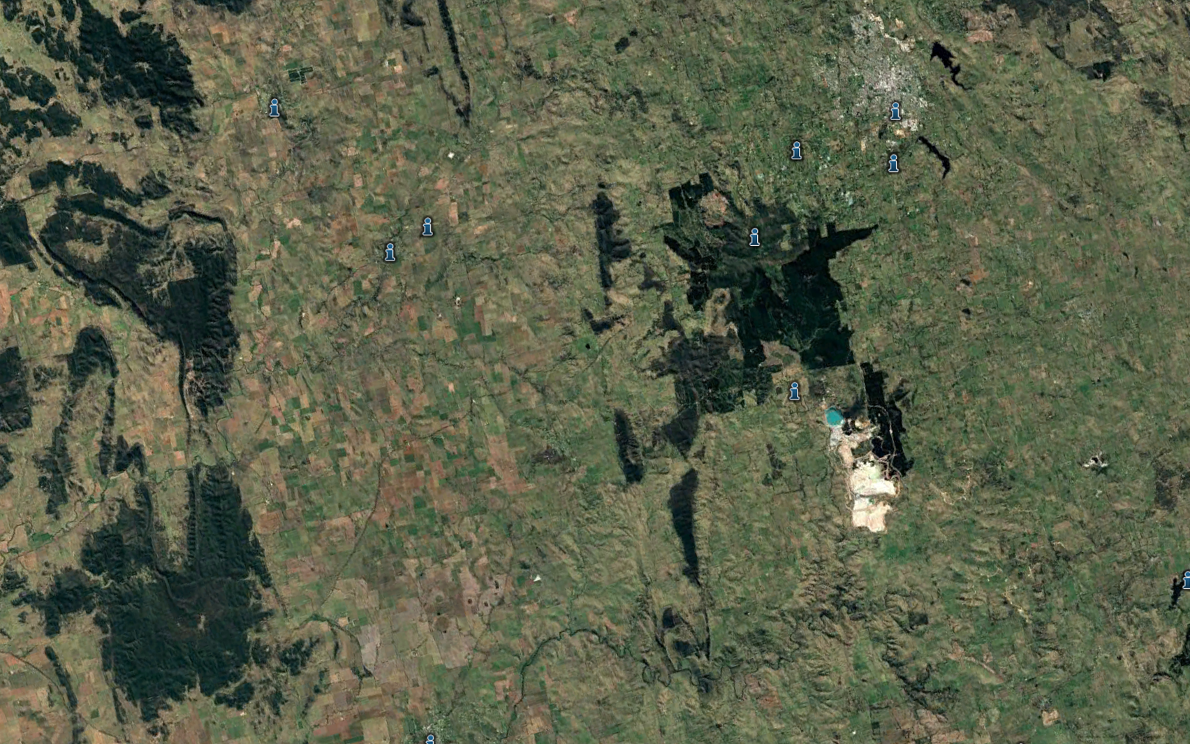
Mount Canoblas the centre of a drainage catchment I visited and videoed in 2010 and pointed out the problems that would eventually result in a disastrous flood in 2022
Mount Canobolas is the centre of all the streams radiating out from this map. Mount Canobolas volcanic soils a very porous and surface water is collected underground in the fractured rock aquifers covering this entire area.
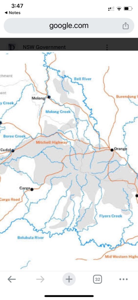
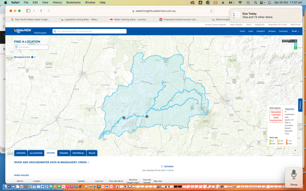
The blue shaded area on this map which is the Mandagery Creek catchment contains some of those streams radiating out from Mount Canobolas potentially carrying water right to the Lachlan River below Eugowra
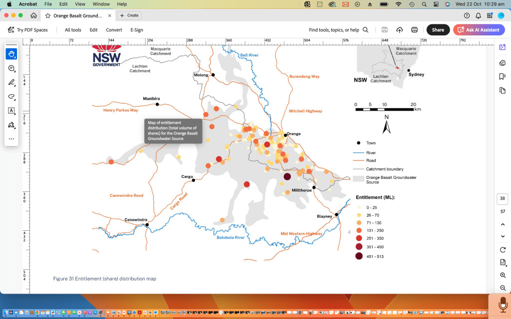
Map of entitlement distribution (total volume of shares) for the orange basalt ground water source. This water source is adjacent to the Mandagery Creek water source.
I wrote the following poem. I videoed the above video. Recorded the above audio all in 2010. Pointing out the problems of overuse of our vital ecsystems 15 years ago.

 Google earth doesn't lie

It's shows the earth from the sky
.
 The Upper Lachlan catchment isn't flat

 we can be sure of that.

What I see. No tree,

only water carved wrinkles
.
Free to carve deeper

. Run water run and scour.

It's a joke that you can no more soak

Look, look down at the manhandled Mandagery


It's a shame.

It's just a drain.

To speed the rain.

 Sudden storm like an express train

. Winds it's way to a salty end on the Lachlan plain.

We've got the brains to slow the rains
.
 And there are some good souls go to pains

. As a bystander I am shocked

  by the stocks impact.

Piecemeal it won't heal.

How much floggen and delog'n
.
How much pug'n and bog'n.

Join together.

 Make a chain to restrain the flow
.
 A chain of land owners to recreate the chain of ponds

. A chain of resistance to stock
.
  A virtual lock on vulnerable land.

 Collar the cattle.

Shock the stock of that block.

Give them some other till it can recover

. GPS not only a factor in steering ya tractor

. Steers the stock.

 They yield to a virtual field.
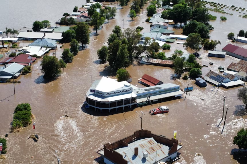
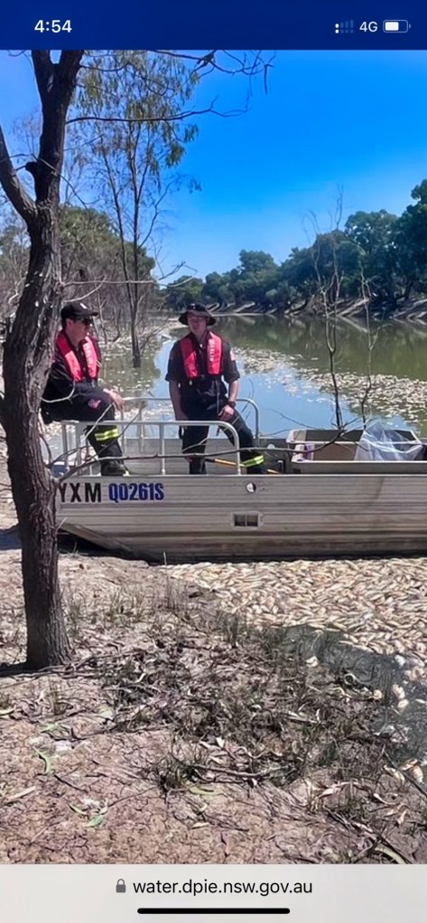
photo curtesy ABC news.
Eugowra. Main Street during the 2022 floods.
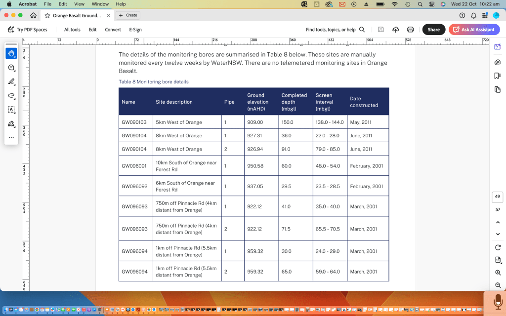
look at the monitor bores around Mount Canobolas groundwater catchment
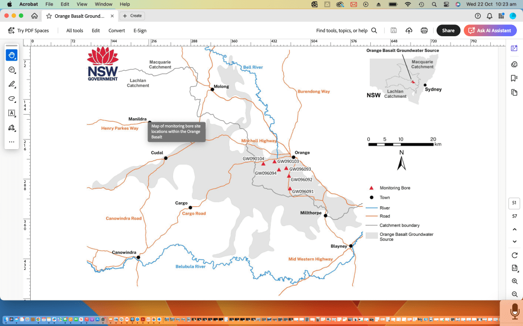
Look at the extent of the catchment called Mount Canobolas groundwater
All of the lachlan catchment surface water sources
Extraction rates from bores around Mount Canobolas ground water source
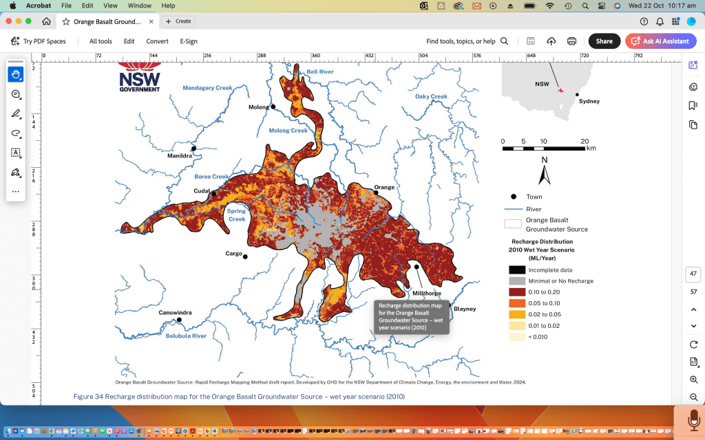
Recharge of Canobolas ground water sources in good years
Recharge of Canobolas ground water sources in poor years
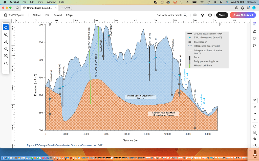
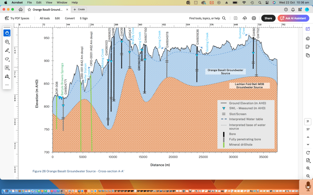
Bores in the Canobolas ground water source and also the Lachlan fold belt fractured rock water source
More bores in the Canobolas groundwater source
I acknowledge that use of data from Google Earth and the New South Wales government websites
THE RESURRECTION OF LAKE CARGELLIGO. It had been dry for awhile. This video was taken on fifth of February 2010 as rains started to fall.
by:
Edgar T. Vagg

Eddie's editing take.

I watch a scene on the screen.

A resurrection of a lake.

On the third month it rose again from the dead.

The camera zoomed in on the distant shoreline.

I'm taken aback with the flood of emotion at the flood of water and its motion. Taken back to my childhood playground. Oh! Wading summers, willow summers, white-capped waves wash over wallowing wags. Whooping and wailing.

Yesteryear as sharp as the smell of weed and water and waders, pardalot and coots and water rat under willow roots.

Show me more for my memory store.

The camera zooms the placid waters.

Rowing and bailing, becalmed.

Sailing and bailing, gibeing and leaning and reaching in a choppy southwester. Shocked by the cool wet spray on a scorching summer's day.

Now shocked by the power of emotion.

An old friend has risen from the dead. Resurrected by moisture from the distant ocean.

Lake Cargelligo
Lake Cargelligo risen from the dead on the 15th February 2010
This poem was written and recited about 2013. It was posted to YouTube at that time. It can be found under my YouTube name Edvagg
We are all on the blunder bus.
All brandishing a blunderbuss a blunderbuss. Blowing out our brains to the strains of "We shall overcome" There's a blunderbuss of regulations
Coming from nervous nations Be aware, cosmic care Is there The force that sets the course The unconscious cosmic influence Surges through humanity. Devoid of vanity Everybody cheers the blundering bus.
There's very few jeers for the blundering bus Science drives the blundering bus Its an atomic powered blunderbuss Not the gun-powdered one of old Ignorance is onboard the blundering bus Parliamentary Acts are a blunderbuss of regulations They're coming from nervous nations All designed to deploy and destroy opponents that annoy Don't despair, cosmic care Is there. The force that sets the course The unconscious cosmic course Surging through humanity. Devoid of vanity Sages throughout the ages have written and still do With this power of intuition often thought taboo, pages and pages of music and verse From their pen to you Steering us from the god of reason Throughout every season.
Here, from my pen to you
without further ado:
I'm cold in this cocoon of warmth. I'm deflated in this pumped up world. I'm not worshipping the god of reason I'm considered unreasonable. I'm looking in a cave but finding no monsters. I'm looking to the mountains and see no gods. The ancient spirits have abandoned us disbelievers. No ancient altars of sacrifice to appease the gods. But there are sacrifices. With a stroke of a pen more powerful than a bolt of lightning a rainforest is sacrificed to the god of reason.
There's no native gods to pull us into line. To smote us with plagues. To point the bone at our unearthly throne. They have been disposed of Dispossessed. Dismissed from their custodial duties. There's great fears for the land they nurtured well The land despairs Rainfall repairs.
With the Gods gifts of bounteous rain What do we do? Inflict more pain What do we do? Gain more gain For the gravy train Its reasonable to run with the gods gifts Its reasonable to run down rangelands Its reasonable to run with excesses Run a race horse Run off to the races Rearrange your faces Run off the rails
Now, out of their twiggy forest pop holes. Comes the afflicted addicted depicted as lost souls The God of reason,* our new mythical monster In the form of a blind mole surges forth Emerges from the Underground it haunts Usurps these lost souls primitive urges And begins its scourges . Like gaunt emaciated sheep they are sacrificed Captured for the chop Drained of every drop of godliness Resort to splurges depraved urges. Reasonableness resurges No hunt, no hounds. Nature is outward bound In the automated towns. Insulated from the dust storms, norms as the earth warms.
Anarchy abounds in the surrounds. Those with compassion are lashed for a lash'n, leaded or beheaded. Their captors kill at will to satisfy an ill -gotten notion that they are the chosen ones with guns. The appointed, anointed sons of reason Commandos commanding in the killing season.
Holy cow! Stop it now! Bond yourself with the benevolent gods. Reconnect with their world, the sod. They're not unreachable. They're are unpreachable. I implore. Adore Restore Their sanctuary, the savannahs, the woodlands, the rivers And the oh so twiggy forests and Twiggy Forrest's plan for unemployed man** The plan, to have everyone work again with dignity. No mentally degraded. No poor bastard parading jaded In prisons yard. Hard drugs Too hard No poor unfortunate.
The Mythical monsters of old who once kept civilisation from shitting in its own nest, are no more. They have been kicked out the door. But we have created a new one. The devils son
The new Mythic God of Reason conquers nature. Changes the season. Extinguishes species. Lives in its own fecies. And ohhh Brother, rapes its own mother. To man its a mental menace. Drugs his panacea. Its menacing, Subjugating, Subordinating and decimating Mother Earth for all its worth. She has taken a stance, Led us on a merry dance. Thrown her humans out of tilter. They smoke with no filter, Create strife. Live life as if there's no tomorrow, Borrow From the future. If you stand in the way of their loot they'll shoot ya.68 Why, why Do the non humans cry? " human nature we hate ya." Well. we have placed ourselves above them,
We don't love them. We have bared the plains And stopped the rains. No more do our rivers deliver The life giver water as they orta. Flood plain gums we plunder. Their death cracks like thunder. Startles the cockatoo community, Trying to maintain its unity, While we march on seemingly free of impunity. But. We are not so, see, the cracks are starting to show. Watch the wind blow, Desiccating the treeless land, Shifting sand, Temperatures climbing, Species declining. Now the first living thing Throws its hat in the ring. The simple cell Is giving us hell, Bacteria and virus Defy us. Think you can kill us with your chemical stew says Giardia the harder ya try The more we defy. We are one with nature, not one above With no love. She is vulnerable. But when push come to shove, She has a winner They eat us for dinner. The virus Defy us She has these little ones, They have big guns, Fighting on a hidden front A guerrilla stunt. They are winning, Thinning Us. Multiple resistance Ensures their persistence. They frustrate those who think they can dominate, Annihilate. Panicky people are just as liable To re-interperate the bible. The lord told moses on the mountain With the mob below idolising. Take this tablet and you will be on the path to ecstasy.
The bibles been skewed. The message has been misconstrued With modern man As it can. Now we are taking ecstasy tablets, This wandering, aimless lost band still idolising.
Reference: **Article by Jared Owens in the Australian 31st July 2014 "Twiggy Forrest plan" * Youtube clip "Approaching the unconscious" by C.arl Yung
Delivering resilient water resources for all water users in the Belubula Valley.
A 20-year Macquarie-Castlereagh region-specific strategy to improve the security and certainty of our water resources.The department’s Water Group is investigating options aligned with the Lachlan Regional Water Strategy and the Macquarie-Castlereagh Regional Water Strategy. These 4 options include: (The department is working with WaterNSW and Central Tablelands Water on this project.)
a new pipeline between Lake Rowlands Dam and Carcoar Dam to transfer up to 2 gigalitres of water per year, capturing spills and boosting supply
raising the Lake Rowlands Dam wall to increase storage from 4.5 gigalitres to 8 gigalitres
building a new dam 2.5 kilometres downstream of Lake Rowlands
connecting the Belubula and Macquarie valleys through an interregional pipeline.
Note: New South Wales Water has lots of information on these projects. Initially they have presented the four options from the Belubula Project as drought proofing the Belubula. But the last option commencing “connecting” in both projects gives this notion away.
It looks like it’s mainly designed to bolster the Macquarie- Castlereagh Project
It’s not about profit and power; it’s about the people and our precious planet! Join the exhilarating journey of the Plain Train! Puffing Billy, Brilliant Billy, Brainy Billy—schooled at SFX Lake Cargelligo and soaring to the heights of the world’s greatest universities! Now, let’s passionately rally together and awaken the realization that we, as humans, need to rise above our ignorance!
R’esum’e-William Plain. History
2011 Emeritus Professor, Nagoya University of Foreign Studies
1998-2011 Nagoya University of Foreign Studies, professor, Educational Linguistics
1993–98 University of Tsukuba, Japan, professor, Educational Linguistics
1990-93 Niigata University, Japan, professor, ELT
1986-90 University of Torino, Italy, lecturer
1989 Teacher Trainers course at Pilgrims English Language Courses, University of Canterbury (Great Britain)
1987-89 MA TEFL from the University of Reading (thesis: ‘Awareness Training in the MA TEFL classroom’)
1988 University of Reading, Great Britain, teaching on EAP summer course
1985-88 Bank of San Paolo, Torino, Italy, teacher
1980-85 Independent Teaching Service, Geneva, director
1980 Development studies course at the Institut Universitaire des études de développement, University of Geneva (Switzerland)
1978-80 Certificat en français moderne, University of Lausanne (Switzerland)
1978-80 Cours Commerciaux de Genève, Switzerland, teacher
1976-78 University of Minho, Braga, Portugal, lecturer
1977 TEFL course by Pilgrims English Language Courses, University of Canterbury (Great Britain)
1975-78 British Institute, Guimarães, Portugal, teacher-in-charge
1974-75 British Institute, Bologna, Italy, teacher
1972-75 Diplomas (4) in areas of natural medicine from British colleges
1971-73 Export consultancy concerned with SE Asian – Australian trade
1969-70 Australian Department of Trade and Industry, export research
1965-69 BA (major in English Language and Political Science), University of Sydney (Australia)
Dear Bill Plain {my letter to William Plain 8th December 1922 seeking his support}
Re
Letter to Decimillennial Australia:
A Voice to the Nation
This edict of yours so impressed me when I started out to publish a book of Poems and Prose on the demise of the Lachlan Valley in Central Western New South Wales.
I have used it as an adjunct to voicing and reinforcing my opinions by way of poetry and prose.
I did go to school with you at Saint Francis Xavier in Lake Cargelligo.
But a bursary took to you further on.
Sincerely
Edgar Vagg
Ps. I wrote this letter earlier to let you know what I was doing. And now I have this wonderful letter from you. The flooding in the Lachlan is easing. At its hight it broke all records. Broke levies and flooded houses. But mine was high and dry.
{William Plain related to me sixth of December 1922}
Ed,
imagine my surprise to see someone making a contribution for my work on creative discussion, and in doing so providing a connection to a period aeons past when we sat in the same classroom in Lake Cargelligo, as though your gesture somehow establishes that year as a point of departure towards my lifetime of attempting to make sense of a few simple ideas, leading to my website, creativediscussion.org, arising from the insights of thousands of students, and the more recent earthsight.org, attempting to communicate with a much more recalcitrant audience of politicians and decision makers.
Your communication leads me to update my Earthsight project, and, in grateful recognition of your reminder, I have just now added a submission to parliament, “Act on Climate”, that I made in 2020 but hadn’t yet added to earthsight.org. Many thanks.
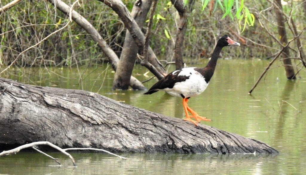
Eddie Vaggs description of this image (The magpie goose. We don’t usually see them in Cargelligo wetlands. But they were here in numbers in 2019 a particularly wet Summer.) Photo courtesy of Craig Cromlin and bureau of meteorology
Looking through my records, I find this email I am now replying to, and your reading of “A Country under the Weather”, with the insightful observation of “a people who knew that no land is won or lost by war”. In today’s moment of constitutional recognition, the assertion that “no land is lost by war” is a positive reminder that Australia has not been lost by a mere 2 centuries of invader wars, not when 2 millennia, 2 decimillennia, more accurately 6 or even 10 decimillennia, have created a civilisation, an exceptional people, with a unique export, a continental civilisation based on peace (peace between peoples and peace with country), as observed by Bruce Pascoe, as well as the transformative “I am responsible for country” (today we need to add: “and planet”).
In many of my Earthsight papers I have included a reminder from ancient wisdom that “insight is the key to creativity”, easily accessible in the simple process of Earthsight Discussion, a term I now use to refer to “Creative Discussion using Plain Pair Groups”, occasionally wondering whether this practice may unfurl the wings of the butterfly of chaos theory.
“Act on Climate” is my latest attempt to make a little suggestion, while “Decimillennial Australia” (earthsight.org, March 2019) indicates who we need to be listening to: the “product of wounded country”, who might even be helped by helping the larger world to actually see.
Decimillennial Australia has probably done this before, recovering from major catastrophes; surely the separation of Tasmania and loss of coastal plains (continental shelf), what we know as the Deluge, was one, and the present ongoing Anglo deluge calls not simply for a Voice to Parliament, but even more, a “voice to the nation”, First People generated and totally independent, arising from creative interaction within multiple communities, which, who knows, might perhaps be facilitated by the “creative ideas (that) ripple out across communities and organisations” of Earthsight Discussion.
Perhaps planetary change can start down along River Road.
Speaking of rivers, I hope you are not being flooded out at the moment. I’ve never driven along River Road, but using Google Earth I can imagine you may be at considerable risk. Murrin Bridge seems to be even more at risk.
On 30 Oct 2019, at 09:43, Edgar Vagg <edvag@me.com> wrote:
Bill.
I met you in Lake Cargelligo at your mother Molly ne Chanter”s funeral memorial service. Was impressed withCreative Discussion using Plain Pair Groups
Bringing Wisdom into Planetary Leadership
The drought and the severe stress created in the Lachlan Valley has brought a small group, Cargelligo Wetlands together. Conventional meetings are still being held and I will eventually bring up your ideas of plain pair groups. At the moment I have another important agenda. To release my book of poems spanning my life experiences in Lake Lake Cargelligo . I’m working on an EPUB for Apple Books of the contents. It’s poems and prose I have written and gathered together over the years . They are mainly environmental. And push the same agenda as you that humans are stupid. I have mentioned your work from
creative discussions.org. I can send you a link for your perusal. It’s a draft at the moment. Created on Pages on an Apple MacBook Pro laptop. I’m aiming to have an impact on citizens attitude towards global warming with its release. At First an E-book with audio readings of the poems on Apple Books and eventually a hard copy with audio included. I’m including a sample poem in audio in a following email.
Edgar Vagg
703 River Road
Lake Cargelligo
NSW
2672
Phone 0428981287
Billy Plains Edict
This his his letter to Decimillennial Australia.
A Voice to the Nation published in Earthsight.org in March 2019
Description of image by Eddie Vagg (Lake Ballyrogan an original ephemeral lake against the Lachlan Range not far from ‘”Atholstane” Bootawa Road where William Plain was raised. It was converted in the 1950s to Lake Brewster water storage linking it to the Lachlan River.)
The already established Anthropocene Mass Extinction, the 6th major extinction, for which the dominant world civilisation is responsible, is now leading us in the direction of exponential global warming and civilisation collapse, or even worse.
We need help, the world needs help, and the urgent need for long-term global sustainability seems to point to First Peoples, and particularly the Australian indigenous civilisation, as among the few who hold the keys to the future. The very long term continuous and highly successful nature of Australian culture and land management over multiple tens of thousands of years means “Decimillennial Australia” needs to establish a “voice to the nation”, to advise on the best way to transform the totality of our civilisation so as to assure that there can be a future. There is a continuum from homo sapiens sapiens to homo stupidens stupidens which englobes whole cultures, entire continents, over centuries and millennia. Ours, the so-called ‘western civilisation’, in many key respects is at the homo stupidens stupidens end of the spectrum.
(Francis Xavier School Lake Cargelligo. William plane received a bursary from here to further his education.)
The Australian decimillennial culture in its historical dimension is undoubtedly at the homo sapiens sapiens end. I am inviting those in the indigenous community with ‘access’, to reach back beyond 1788, beyond the two centuries of destruction and belittlement, back into the depths of that culture, and bring forth the knowledge, the wisdom, the essence of 100,000 years of an ever-developing culture, community and responsibility for the earth. Today, this century, that knowledge may well be the key to the future, the key to there being a future. The new Australian culture of two centuries, along with that of much of the present world, is destroying our planet. That’s the meaning of the term, ‘the Anthropocene mass extinction’, which has its origins with the industrial revolution – about the time the doctrine of Terra Nullius arrived on Australian shores.
Caption
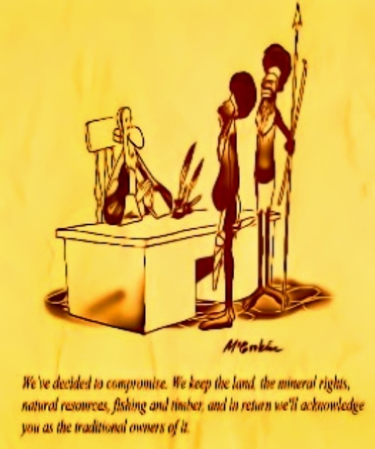
(Governor Phillip. “We decided to compromise. We keep the land. The mineral rights. Natural resources. Fishing and timber. And in return we will acknowledge you the traditional owners of it”.)
We don’t realise what we have done, and don’t know how to change. But our problem is now the problem of all peoples, those who have caused the present situation, as well as those who have always worked to contain the damage and respect the planet. It is to be hoped that the most ancient of those wisdom cultures, perhaps the most peaceful and the most responsible, can now become the guide that can advise our leaders and our people – and find ways to lead them to listen and be informed. Looking at the world today, much of the planet is the detritus of the brutality of the Western search for domination and conquest – ever perfected by today’s corporatocracy, financeocracy and oligarchy. The Earth herself is now looking to you, to the people who have tended the earth for 100,000 years, spanning geological catastrophes that today we seek to ignore, while closing our eyes to similar ecological catastrophes we have already created in ‘our’ epoch of the Anthropocene. The 10 millennia that has seen the development of what is now the ‘western civilisation’ that dominates, destroys and is slowly reducing to detritus the major part of the entire world population and its natural diversity evidently do not carry the seeds of wisdom we are desperately in need of today. On the contrary, the 10 decimillennia of Australian civilisation, the peoples who eschewed the deceptive riches of quantity for the wealth of quality, can present the essential understanding that can lead this country, and the entire planet, to a new world, a world of people and planet, rather than a world of profit and power for the few.
We need your assistance to avoid a futurecide that could be worse than the Permian Mass Extinction. The dominant world culture does not have the answer. Any attempt to avoid the risk of exponential warming while using the same technologies and structures that caused it is doomed to failure. We need something new, something ancient, the wisdom and expert knowledge that guided the most successful and sustainable culture and land management of all time, with its respect for life, for community, for country, for planet. There we may find a guarantee of a long-term future for our grandchildren and their grandchildren, and beyond. This process of creating a new world, a world with its origins in so many and varied traditions of sustainable agriculture and supportive communities around the world, would certainly make judicious use of the multitude of non-impactual aspects of the present world; much of our science and technology and culture can be compatible with a ‘planet with a future’. We also need to sustain a deep confidence in the evolutionary direction of the living planet over 4 billion years of dynamic homeostasis, despite the 5 major extinction events to date. We have now initiated the 6th, the first ever where a single species is uniquely responsible. But because we have caused it, through a species-wide reevaluation of our role in the ecosphere, we can initiate a process of fundamental and radical change that can make the world a much better place to live in, for all, and at the same time guarantee a future, for all. The threat of global warming can dissipate by quickly – very quickly – eliminating the causes of the Anthropocene extinction: the excessive human footprint and the carbon overload as well as the massive exploitation of both planetary and human resources.
To do this we certainly need to reevaluate the type of society and economy, the type of leadership, that have developed over centuries, if not longer. The important work of identifying and promulgating the values and the ways-of-being that can help us to draw back from the brink is the most urgent challenge our species has faced.
It seems this type of world that can guarantee that there will be a future has already existed, perhaps in many parts of the world, but on a very long-term continuous basis it has flourished most importantly in Australia. Today such a world desperately needs to be imagined, guided and nurtured into existence by those who have access in the not so distant past to a living culture that can inform our world today. By itself, our world seems incapable of achieving this.
Eddie Vagg.Member of Cargelligo Wetlands and Lakes inc.
I would also like to acknowledge the Wetlands Warriors in the boat on this cover post. Peter Nilsson and Richie Suckling who have allowed me to use their home turf to explore the Robinson Crusoe island and the extensive Cargelligo Wetlands adjacent to these properties. Photograph by Craig Cromlin
Can we justify. The means of existence. The unbalanced way we disregard all for our own ends. We can and we do despite the evidence to the contrary. We need six planets to sustain our way of life. Then it would still put each planet we invade out of tilter. Because we still haven’t realised the link with every facet of the universe we live in. The chain. The chain of unbroken systems that support all the elements of this amazing planet. The ancient tribes did!.
deep gouged out channels.
drained flood plains.
Bovine belted banks.
No thanks
We can’t deny extraction. That is part of the symbiosis of entities. Every entity relies on something for its existence. It’s the over extraction and destruction of a link that upsets the equilibrium.
I got a plan. The Bureau of Metrology got the wherewithal. Using their regularly updated soil moisture map of Australia. The soil carbon maps of Australia. The saltation studies. The rainfall records.
The northern indigenous tribes have the wherewithall : The reestablishment of native perennial pastures using fire.
My Plan A
The use of GPS collared cattle. The use of Drovers. Remove the fences mental and material.
The wilder beast herds of old in Africa followed the feed across the veldt. And still do.
The bison did the same across America. Their journey ended when they were ere slaughtered by the invaders to starve the Indians out of existence.
The Spanish Shepard’s for thousands of years drove their stock across Spain following the pastures and still do.
Graziers of the Riverina moved their stock to the summer pastures of the high country of the Southern alps. Until they proved a danger to precious bogs.
Kidman the Pastoralist had his properties from northern to southern Australia to take advantage of Northern Rains of summer and the southern rains of winter.
We with modern technology could have our herds follow the feed.
The square paddock mentality for cropping and grazing brought to this great Southland from European conditions. Conditions that even European farmers are finding are destructive. It has to change. Cell grazing would work close to major centres where compost is available to regenerate tired soils.
Saltation of our land and water was held in check by our First Nation people knowingly or unknowingly by the way they used the land and its waters
Our settlers knowingly or unknowingly have left a timebomb . That time bomb was salination. Salt was ubiquitous in the Australian environment. It resides in our marine origin sedimentary rocks and saline ground water. Tree cover. perennial grasses and native farmers kept the system in this variable climate in sync .
It’s not to late to On riverside, log jams and overflows on floodplains maintained wet marshy swamps and billabongs*. This environment kept salt from surfacing. The soggy flood plains refreshed our fresh water streams and aquifers . They remained seeping and weeping through droughts. The rivers scour now freed of log jams. Just a channel for water orders to arrive on time. Bowmaster
A huge study of salt in the environment has been undertaken since European settlement. Today we have the bad news from minister of environment and heritage that this time bomb like land mines is being triggered by our land use and we have to change the way we do things.
While southern Australia shows little shift towards wetter or drier conditions for Autumn 2019 the past two to three decades have seen a decline in autumn rainfall. For example, from 1990, 24 of the 29 years have brought below average rainfall to southeast Australia (below the 1961-1990 average).
In addition to the natural drivers such as the El Niño–Southern Oscillation and the Indian Ocean Dipole, Australian climate patterns are being influenced by the long-term increasing trend in global air and ocean temperatures. SAM a system in the southern ocean is moving our southern fronts further south.
*Peter Andrews (rebuilding wet floodplains)
I can see the answer to disillusionment.
But i dont want to put my finger on it. It feels as if it would alienate me. Isolate me from where i am or imagine i am in my community.
I see the problem and the answer as divisive.
(Excuse me there is a willy wagtail knocking on my window). Oh he’s just picking last nights trapped insects off
the window. One of these days i will learn to communicate with them. (Love their energy.)
I suppose that is my view of the world as a human. Nothing in the cosmos is alien to me. Every thing is a link in the chain. Broken disillusioned people are broken links.
Trauma
I don’t expect any of us from the environment we call lake Cargelligo have anything to do with the trauma that was inflicted on the first people after the first fleet arrived. It’s the present day traumas that are perpetrated. These are the ones we are responsible for, as a people’s . As people’s, we can do something about. Do something about the traumas here and now. If we don’t then we are as guilty as our forebears.The traumas that exist in this community have their roots in natural ecosystems that Lake Cargelligo is so blessed with. Human beings need the natural environment to maintain equilibrium. Every thread of existence every thread of this web every ounce of our being depends on this web.
There’s other ways to pull away from a depressive road. At present too many are falling, crushed by the pressure to conform. Conform is the norm when it comes to violence. It’s normal to bash your partner to be big amongst your mates. Crowing to them that she gets what she deserves. Nailing the perpetrators. Is hard. Jailing the perpetrators is harder. Community unity to change the culture. Destroy the vulture who preys on our mind. We can all write. Express yourself. Honestly write what is depressing you. Write what’s makes you happy. We can put all these community stories together. Put them together on stage in the old theatre to expose our lack of understanding as a community
Three articles by Conversations journalists clarifying Uluru statement from the heart. Headed by a plea by Post author Eddie Vagg in the form of a poem.
Eddie Vagg’s poem First People inspired by ancient campsite, cries out for Truth Telling
I'm not kidd”n

I walk across an ancient midden.

I feel I just want to throw a spear.

There is something here.

I know about this tragedy.

But this is not a parody.

There is a spirit in this clay pan

where a spirited race once ran.

The flint flakes

Shells from Rivers and lakes

And the honing stone

Petrified bone.

An energetic race once called this spot home.

The energy is sometimes there.

Strongest in the spring morn.

When they had the cool late winter burn

 green shoots would return.
then the roo’s were Ambushed and speared.

I amble further on

the energy is gone.

So has the tribe.

Sulphur Crested’s

The messenger bird

Rested in the trees.

their late evening screeching

smacks of violence

And the campfire silence
The Voice: what is it, where did it come from, and what can it achieve?
This is the first article in our three-part series explaining Voice, Treaty and Truth.
This week, the government will introduce a constitutional amendment into parliament to establish the Aboriginal and Torres Strait Islander Voice. If successful, it will go to a referendum likely in October or November.
We now know the wording of the amendment and referendum question the government is proposing. But what exactly is the Voice? Where did it come from? And what it can achieve?
What is the Voice?
The Voice provides permanent representation and recognition for Aboriginal and Torres Strait Islander peoples in the Constitution.
The Voice will be a new body that represents Aboriginal and Torres Strait Islander people from across Australia to provide their input into the decisions, policies and laws that are made by the government and parliament.
This is consistent with the UN Declaration on the Rights of Indigenous Peoples, which says Indigenous peoples have a right to participate in government decision-making in matters that affect their rights, through their own political institutions.
Across the world, similar types of institutions and relationships have been established, including in Sweden, Norway and Finland with the Sami people, and with the Māori in Aotearoa. There are also many similar relationships that Indigenous peoples have with the state in North and South America.
However, it’s also important to remember the Voice has been developed as a response to our local circumstances, and in particular, the lack of formal agreement – such as a treaty – or formal recognition of the rightful place of First Nations in Australia.
In Australia, the Voice will be constitutionally enshrined. This means successive governments can’t overturn it. It will be established as a new constitutional body in a new chapter (Chapter 9) at the end of the Constitution.
The key function of the Voice – to make representations to the government and parliament on matters relating to Aboriginal and Torres Strait Islander people – will also be constitutionally protected. But the government and parliament cannot be compelled (for example, through litigation) to follow these representations. As such, this body would not have “veto” power and is not a “third chamber”.
Rather, the Constitution is setting up a mechanism designed to improve decisions, policies and laws through First Nations input on matters that affect them. These matters might directly affect Aboriginal and Torres Strait Islander people, such as changes to the native title law, but it could also include broader laws and policies that have a particular impact on them, such as environmental protection laws or electoral laws. These decisions would be improved through their input.
Other details about the Voice will be decided by parliament through the normal legislative process. This ensures the Voice’s design can be flexible and evolve as required. These details include:
how many representatives will comprise the Voice
how they will be selected
what its internal processes will be
what powers it will need to perform its functions, such as accessing government information, and
how the Voice will interact with parliament and the executive.
As many constitutional experts have explained, establishing the key principles and leaving the detail to be determined through the legislative process is a normal – and desirable – way to design constitutional institutions.
That is not to say we don’t know what the Voice will look like – there has been significant work done on this. Most recently, the government has released a set of principles that will guide the initial legislative design of the Voice, should a referendum be successful.
The Voice also performs another important constitutional role: it recognises Aboriginal and Torres Strait Islander people as the First Peoples of Australia in the Constitution. At the moment, the Constitution is entirely silent with respect to Aboriginal and Torres Strait Islander people.
Where did it come from?
The Voice has been proposed by Aboriginal and Torres Strait Islander people as the best solution to respond to their overwhelming feeling of disempowerment and structural disadvantage.
The concept of the Voice, when understood as recognition and representation, has a long history. The advocacy for greater political representation for Aboriginal people stretches back to a 1938 petition organised by Yorta Yorta man William Cooper.
The modern advocacy for constitutional recognition stretches back to Prime Minister Paul Keating’s response to the 1992 High Court native title decision known as “Mabo”. This included a social justice reform package that recommended constitutional recognition, to be determined through a series of conventions and negotiations with Aboriginal and Torres Strait Islander people.
This never happened, however. It wasn’t until 2010 that constitutional recognition was raised again as part of Julia Gillard’s minority government negotiations with independent MP Rob Oakeshott. This resulted in the establishment of the Expert Panel on Constitutional Recognition of Indigenous Australians, which reported in 2012.
The panel recommended recognition should be achieved through a series of changes, and most controversially a clause in the Constitution about racial non-discrimination. The Labor government never responded to the proposal and the Coalition dismissed it as a “one-clause bill of rights”.
Following this, in 2015, Aboriginal and Torres Strait Islander leaders developed the Kirribilli Statement, which requested a new set of consultations to break the stalemate on recognition.
This led to the bipartisan establishment of the Referendum Council and a A$10 million commitment to undertake nationwide consultations with Aboriginal and Torres Strait Islander people – as had been proposed back in the 1990s but never happened – as well as non-Indigenous consultations.
At the same time, groups like the Cape York Institute under Noel Pearson began significant work on a proposal for an Indigenous representative constitutional body, which would lay the conceptual foundations of the Voice. This included the development of some initial drafting by constitutional expert and professor Anne Twomey.
The Indigenous members of the Referendum Council, under the leadership of Aunty Pat Anderson, Megan Davis and Pearson, designed a series of locally led dialogues to understand the reform priorities of First Nations people across the country.
Each dialogue selected representatives to attend a First Nations Constitution Convention. After days of negotiations over such pressing questions as sovereignty and how best to achieve aspirations like a treaty, the convention endorsed the Uluru Statement from the Heart.
This called for two stages of reforms. First, a constitutionally enshrined Voice. Second, Makarrata, which is a Yolngu word for “coming together after a struggle”, to include agreement-making (a treaty) and truth-telling. Voice. Treaty. Truth.
What can it achieve?
The Voice is both a practical and symbolic reform.
Practically, the Voice is informed by decades of research and the experience of people on the ground, that decisions, policies, laws and most importantly outcomes are improved when Indigenous peoples are empowered and involved in the process.
Symbolically, the Voice offers Australia a chance to design a more inclusive narrative of nationhood, informed and strengthened by the participation of First Nations people.
In Australia, we have tried to address these issues before, including through bodies like the National Aboriginal Consultative Committee and the National Aboriginal Conference in the 1970s, the Aboriginal and Torres Strait Islander Commission (ATSIC) from 1990-2005, and smaller ministerial advisory bodies.
These bodies did good work and made a real difference, despite having limited power and resources. They often faced hostile political environments where a change in government would undermine the progress made.
But none of these bodies were enshrined in the Constitution, and each was dismantled, often at times of heightened political tension with the government. So, Aboriginal and Torres Strait Islander people were not able to have independence, stability, continuity or the necessary capacity to engage with government in a meaningful, ongoing way.
The Voice offers a highly practical reform, which for the first time will offer independence and stability through constitutional enshrinement.
The Voice is also an important stepping stone towards other key reforms in the relationship between Aboriginal and Torres Strait Islander people and the state – in particular, treaty and truth as described in the Uluru Statement.
The sequencing of Voice, Treaty, Truth has been given significant thought.
Voice precedes Treaty because fair, modern treaty negotiations require first the establishment of a representative Indigenous body to negotiate the rules of the game with the state. It can’t be left to the state alone, and the state must have a group of people with whom to negotiate.
In Victoria, this was achieved through a specific representative institution – the First Peoples Assembly.
Truth follows Voice and Treaty, because, as Torres Strait Islander political scientist Sana Nakata explains, Voice ensures Truth will matter more than just “continued performance of our rage and grief for a third century and longer”. Voice establishes the power for Treaty, and Treaty establishes the safekeeping of Truth.
As historian Kate Fullagar explains, truths about Indigenous history in Australia are well-known – there have already been royal commissions into colonial violence, the stolen generation, and Black deaths in custody. But they have been too easily forgotten, and they have not led to change.
The Voice presents an opportunity for improving the relationship between First Nations and the State through stable political empowerment that will give all Australians an opportunity for a better, shared future.
Lecturer, Griffith Law School, Griffith University
Disclosure statement
Gabrielle Appleby is a member of the Indigenous Law Centre at UNSW (Sydney). She served as a pro bono constitutional consultation to the Regional Dialogues and First Nations Constitutional Convention that delivered the Uluru Statement from the Heart.
Eddie Synot is a Senior Engagement Officer with the Uluru Dialogue and a Centre Associate with the Indigenous Law Centre at UNSW (Sydney).
First Nations people have made a plea for ‘truth-telling’. By reckoning with its past, Australia can finally help improve our future
What actually is a treaty? What could it mean for Indigenous people?
This is the second article in our series explaining Voice, Treaty and Truth. Read the first article in the series here.
The Uluru Statement from the Heart calls for Voice, Treaty and Truth. These aspirations are intended as a sequence of reforms, that advance towards a just settlement with First Peoples.
The federal government is committed to holding a referendum later this year to put an Aboriginal and Torres Strait Islander Voice in the Australian Constitution. The government has also agreed to implement the Uluru Statement “in full”.
Following the referendum, it’s expected attention will shift towards a Makarrata Commission to “work on a national process of treaty-making and truth-telling”. In fact, reports suggest the government might move even faster.
But while Treaty has long been part of the political landscape, it is not well understood. Many Australians wonder what a Treaty is, what it would achieve, who it would be negotiated with, or for whom, and how. We’ll explore some of these questions here (in brief).
Why does Australia not have a Treaty?
When European colonial powers encountered Indigenous peoples, they often negotiated treaties. These agreements dealt with a range of matters, including trade and military alliances. They also set out rules to share the land and maintain peaceful relationships.
These colonial-era treaties were regularly broken. However, they recognised Indigenous peoples had the right to deal with land and exercised sovereignty over that land.
The British did not engage in treaty talks in Australia. They never sought to negotiate with the owners of this land. Instead, they claimed the land belonged to no one and took it for themselves.
Historians have debated why the British took this approach. Some have argued as a penal colony with a substantial military force there was no need to negotiate trading relationships with the original owners. Others have argued the racist attitudes of the day were influential.
Whatever the reason, the result is Australia is an outlier. As a result, many Aboriginal and Torres Strait Islander peoples believe the moral and legal basis of the nation is “a little legally shaky”.
What is a Treaty?
The absence of a Treaty is one of the major challenges facing the Treaty debate in Australia. Without a history of treaty-making, the concept of what a treaty is or involves remains vague for many people, including government.
It means some people can argue a Treaty is dangerous or it would lead to the breakup of the nation. This makes little sense because a Treaty is a marriage not a divorce. It’s about bringing communities together and building strong relationships based on self-determination.
Governments might argue they’re already engaged in treaty-making. There are many examples of bureaucracy adapting its policy formulation and delivery to reflect community aspirations for a greater say in the delivery of services.
Such “partnerships”, “co-design” and local decision-making with government are valuable. They mark an important shift in promoting Aboriginal and Torres Strait Islander peoples’ participation in policy development and service delivery. But simply calling an agreement a “treaty” doesn’t make it a treaty.
Australia has signed up to a range of international legal instruments that concern the rights of Indigenous peoples. These legal instruments set a clear standard for what makes an agreement a treaty. A treaty must satisfy three conditions.
A treaty acknowledges Indigenous peoples are a distinct political community different to other Australians. This is because Indigenous peoples are the only group of Australians who owned, occupied, and governed the continent before colonisation. This recognition also acknowledges the historic and contemporary injustices that invasion has caused
A treaty is a political agreement reached by a fair process of negotiation between equals. Negotiation helps ensure everyone’s interests can be considered. But securing a fair negotiation process can be difficult. In Victoria, the First Peoples Assembly and State government have agreed to a Treaty Negotiation Framework that sets out principles to guide Treaty talks
Treaties involve both sides committing to responsibilities, promises and principles that bind the parties in an ongoing relationship of mutual obligation and shared responsibility. Most importantly, while the outcomes of any negotiation will differ according to the parties, a treaty is built on the recognition of Indigenous peoples’ inherent sovereignty. As part of this, a treaty will provide for some degree of self-government. What this looks like in practice will be worked out in negotiations.
A treaty will also include a range of other elements. It could include financial compensation, return of land, formal recognition of historic wrongs, and symbolic gestures of reconciliation, such as apologies.
Treaties are unique agreements. As Professor Megan Davis explains, they are aimed at “settling fundamental grievances, and establishing binding frameworks of future engagement and dispute resolution”.
Modern treaties are different from historic treaties
There is a long history of treaty-making all over the world from which Australia can draw lessons. But it’s important to note modern treaties differ from those negotiated in colonial periods. They are more technical and legally complex. They are also negotiated against a long history of inequitable relationships.
They will also be subject to Australian law. While colonial-era treaties were international agreements between two sovereign communities, modern treaties will be subject to Australian law.
Progress has been slow, but important steps have been taken at the state and territory level. For instance, in February this year, the Queensland government introduced the Path to Treaty Bill 2023 into the state parliament. The bill will establish and finance an independent First Nations Treaty Institute to “help prepare and support First Nations people for treaty negotiations with the state”.
That same month, the South Australian government introduced a bill to establish a Voice to the Parliament, with a treaty process to follow.
In Victoria, after several years of patient work, negotiations between the First Peoples Assembly and state government are expected to begin by the end of the year. Similar processes are underway in the Northern Territory, Tasmania and the ACT.
Every treaty process has its own challenges and complications and it’s too early to tell whether these processes will result in meaningful settlements. Nevertheless, they demonstrate two key things.
First, Treaty is a matter of political will, not legal impossibility. Second, looking towards the referendum later this year, the existence of treaty processes across the country suggests Australians may be willing to deal with the unfinished business of colonisation and its consequences.
Lecturer, Faculty of Law, University of Technology Sydney
Disclosure statement
The authors do not work for, consult, own shares in or receive funding from any company or organisation that would benefit from this article, and have disclosed no relevant affiliations beyond their academic appointment.
State refusals to respond to truth have led to renewed calls for processes that will detail the impacts of colonisation in the everyday lives of Indigenous people. These calls were an important part of the Uluru Statement from the Heart, which sought “the establishment of a First Nations Voice enshrined in the Constitution”, complimented by “a Makarrata Commission to supervise a process of agreement-making between governments and First Nations and truth-telling about our history”.
As legal scholars Gabrielle Appleby and Megan Davis have commented, the call for truth-telling in the Uluru Statement is just one part of a wider call for structural reform intended to ensure improvement in the lives of Aboriginal and Torres Strait Islander people.
Why truth?
Beginning in the 1980s, formal truth-telling processes (usually called truth commissions) emerged as a method of reckoning with the past in deeply divided societies around the world. Perhaps the most famous example is the South African Truth and Reconciliation Commission, which aimed to address the gross violations of human rights that happened under apartheid.
Truth commissions like this are generally temporary, state-sanctioned inquiries that typically last from one to five years, with a remit to investigate particular events and examine specific violations over a defined period of time. This typically involves collecting testimony from victims and (sometimes) perpetrators.
It is only relatively recently that truth-telling processes have been used as a response to settler colonial violence, most notably via Canada’s Truth and Reconciliation Commission, which arose after a class action lawsuit on behalf of the roughly 150,000 First Nations children taken from their familes and placed in residential schools.
The Uluru Statement isn’t the first time First Nations on this continent have called for truth-telling. Since colonisation, Indigenous peoples have insisted that Australia must not look away from their experiences of dispossession and survival.
When these truths have been told, however, they have all too often been met with denial, defensiveness or even aggression. For example, when the Stolen Generations inquiry pointed to evidence of the forcible removal of Indigenous children that, it charged, constituted a breach of the UN Convention on Genocide, there was an immediate conservative backlash. The Howard government rejected the findings of the inquiry in one of the earliest salvos against what conservatives have termed a “black armband” view of Australian history.
There is a reason settler governments have been reluctant to engage in truth-telling. First Nations often seek truth as a means of changing an untenable status quo, reshaping society’s attitudes so as to improve their own future prospects and reaffirm their distinct sovereignties and their right to self-determination.
As the non-Indigenous Canadian political scientist Courtney Jung has argued, while settler governments may try to use the conclusion of a truth commission to “draw a line through history”, First Nations seek to build “not a wall but a bridge”, using truth-telling to “draw history into the present, and to draw connections between past policy, present policy, and present injustices”.
Whose truths? What truths?
Broadly speaking, First Nations peoples seek truths that address three key themes: narrative and memory; trauma and healing; and responsibility and justice.
We have described this potential as “the promise of truth”, in which truth-telling leads to a kind of agreement between Indigenous and settler peoples, rather than being a process centred on the state and its violence.
The promise of truth is that it will change national narratives and produce a new, shared collective memory that acknowledges crimes of the past; it will contribute to the healing and recovery of Indigenous people who have been harmed by colonisation and dispossession; and it will compel settlers and their institutions to take responsibility for the harms of colonisation.
This approach stands in contrast to what we have called the “colonisation of truth”, through which truth-telling is seen primarily as rehabilitative of the settler colonial state while obscuring ongoing injustices. When truth is colonised, it may reproduce narratives that restore aspects of settler legitimacy and treat injustices as being solely in the past. Alternatively, this version of truth may treat First Nations people merely as victims, telling stories of harm and trauma without delivering reparation. Or it may suggest that the demand for responsibility and justice has been fulfilled simply by engaging in the truth-telling process, rather than treating the telling of truth as a starting point for a fairer future.
Truth, then, is complex, and what it may achieve in the Australian context is not yet clear. As treaty processes progress in several Australian jurisdictions, the commitment to truth-telling seems likely to be a part of future negotiations. This close connection between treaty and truth is unique to the Australian case and confirms the strongly held belief that truth has transformative potential. We do not yet know whether the linking of truth and treaty will produce the transformation in relationships that is so urgently needed.
Victoria, which announced a commitment to treaty in 2016, is the jurisdiction most advanced in testing this proposition. In 2022, Victoria established the Yoorrook Truth and Justice Commission (Yoorrok is a Wemba Wemba word meaning “truth”), marking a new era in Australian truth-telling focused on the history of invasion and colonisation of First Nations’ territories. Until the creation of Yoorrook, no previous commission, royal commission or inquiry into colonisation in Australia has included the word “truth” in its official title.
Yet still, truth is not a straightforward proposition. “Truth burns,” as Indigenous academic Marcia Langton recently put it. Sometimes, truth-telling is painful and connects directly to harm and injustice.
Truth is tricky. It can appear to open spaces for new understandings, while simultaneously shutting these spaces down and reinforcing the colonial status quo.
Ultimately, truth-telling is uncomfortable but necessary, as change in any relationship inevitably is. But this is where the possibility lives. As new truth-telling takes place across this continent we have an opportunity to imagine what it might mean to be in a relationship that does not deny the truth of First Nations’ lives, or the truth of how Australia has come to be.
Professor, School of Social and Political Sciences, Co-Director, Indigenous-Settler Relations Collaboration, The University of Melbourne
Disclosure statement
The authors do not work for, consult, own shares in or receive funding from any company or organisation that would benefit from this article, and have disclosed no relevant affiliations beyond their academic appointment.
To bring you up-to-date on this post. If you are interested in Frank Brennans article . He was a noted participant in constructing approaches to the voice. This article is awash up of the failed referendum vote. This article is available on Apple Books
Sunset after the flood 2/3/2023. Environmental water flowing past My home on 703 River Road lake Cargelligo to protect the lower Lachlan from the sudden
dry
Galari ( Lachlan River)
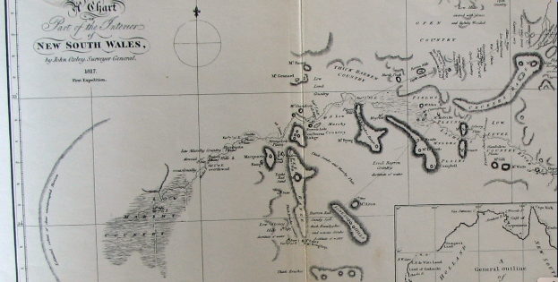
It is the basis of my book Cargelligowetlands(see LachlanRiverlung.com) this Lachlan River in Central Western New South Wales . The large piece of prose in the book “Bastardisation of a magical river” looks at it from Oxley’s Diary angle and my angle expounding it’s flatness. It’s flatness are unique feature of a river that runs over most of its length.
Bastardisation of a magical river revisited
We didn’t realise it’s magical ability to store water through its whole length.
Bastardisation by coloniser Creations for convenience.
Made from shortsighted civilisations Returning negative results to our precious environment.
This essay:
I’m using Oxley’s journal of his journey down the Lachlan in 1817 to find out the true nature of this once pristine unique River System.
I’m using this approach to show where we have gone wrong.
This maybe an aid in embracing some of the rights and fixing some of the wrongs.
My comment: The following paragraph is the description by Oxley on his arrival on the Bathurst plains in 1817. Perfect example of how early settlers overran the excellent food resources maintained in a sustainable way for millions of years by the aboriginals at the very top of the western catchments.
Journal 14th April:: Bathurst had assumed a very different appearance since I first visited it in
the suite of his excellency the Governor in 1815. The industrious hand of man had been busy in improving the beautiful works of nature; a good substantial house for the superintendant had been erected, the government grounds fenced
in, and the stack-yards showed that the abundant produce
of the last harvest had repaid the labour bestowed on its culture. The fine healthy appearance of the flocks and herds was a convincing proof
how admirably adapted these extensive downs and thinly wooded hills are for grazing, more particularly of sheep. The mind dwelt with pleasure on the idea that at no very distant period these secluded plains would be
covered with flocks bearing the richest fleeces, and contribute in no small degree to the prosperity of the eastern settlements.
My comment: Aborigines. There hunting ground decimated for the woollen mills of Britain
My comment: The following paragraph of Oxley’s journey gives an example fire control the aboriginals of the Lachlan tribes practised. The other items mentioned is the drainage by limestone to take water under ground into the aquifer. The beginning of what I’m trying to explain about water the whole length of the system being stored
Journal 23rd of April: The timber standing at wide intervals, without any brush or undergrowth, gave the country a fine park-like appearance. I never saw a
country better adapted for the grazing of all kinds of stock than that we passed over this day. The limestone, which is the first that has hitherto
been discovered in Australia, abounds in the yy where we halted; the sides and abrupt projections of the hills being composed entirely of it, and worn
by the operation of time into a thousand whimsical shapes and forms.
A small stream runs through the valley, which in June 1815 was dry; the bottom of this rivulet was covered with a variety of stones, but the bases of the hills which projected into it, and from which the earth had been washed, were of pure limestone of a bluish grey colour.
My comment: Limestone country. Waterhole 14 miles from the Lachlan and no more water till the river. Must’ve gone into groundwater
My comment: Oxleys description On his arrival at the head of the Lachlan.
Journal 25th of April: At two o’clock saw the river, which certainly did not disappoint me: it was
evidently much higher than usual, running a strong stream; the banks very steep, but not so as to render the water inaccessible: the land on each side quite flat, and thinly clothed with small trees; the soil a rich light loam:
higher points occasionally projected on the river, and on those the soil was by no means so good. The largest trees were growing immediately at the water’s
edge on both sides, and from their position formed an arch over the river, obscuring it from observation, although it was from thirty to forty
yards across. At four o’clock we arrived at the depot.
My Comment: 25th April Oxley’s first sight of the Lachlan {and just short of their starting depot just beyond Cowra} in its high reaches, good description obvious floodplain and river banks and streamflow
My comment: The following paragraph gives the position of the depot where they begin the journey down the Lachlan . It was near Cowra the foothills of the catchment. 150m above sea level. Booligal near the other end of the catchment is 90m above Sea level. The unique gentle slope and geology mimics the flows of the Lachlan. This reasonably gentle slope enables storage for some time of water in swamps and groundwater for the whole length
Journal 27th of April: The observations which were made here placed the depot in lat. 33. 40.
S., and in long. 148. 21. E., the variation of the needle being 7. 47 E. The barometrical observations, which had been regularly taken from Sydney to this place, did not give us an elevation of more than six hundred feet above the level of the sea; a circumstance which, considering our distance from the west coast, surprised me much
My comment: The following paragraph highlights my proposition. There was plenty of harbour for Fish. Plenty of logs for slowing down the flow. Large shallow lagoon suggests shallow groundwater and there was plenty of birdlife in a stable ecosystem
Journal 29th of April: At six o’clock the boats arrived safe, the men having had a very fatiguing
row, and been obliged to clear the passage of fallen trees, and other obstructions; so that we determined to give them some repose, and halt
here for the night. At half past eight o’clock proceeded down the river, intending to stop at the termination of Mr. Evans’s journey in 1815, about
five miles further, for the purpose of repairing the small boat, which had sustained some slight damage in coming down the river yesterday. I rode
about three miles back into the country; the cupressus was here more frequent, though not of large growth; the soil is not good. In returning to the river we came upon the creek which terminated Mr. Evans’s journey,
down which we travelled until we came to the river, about half a mile from which is a large shallow lagoon, full of ducks, bustards, black swans, and
red-bills. At twelve o’clock the horses arrived at the mouth of the creek, and the boats half an hour afterwards. The banks of the creek were very
steep, and it was three o’clock before all the provisions were got over. The creek was named Byrne’s Creek,(Belubula River )after one of the present party, who had accompanied Mr. Evans in his former journey
My comment: The following sentence was made in the journal a day or so further on from Belubula confluence. Showing more proof of groundwater.
Journal Second of May: Upon the swamps were numerous swans and other wild fowl. In the evening we caught nearly a hundred weight of fine fish.
My comment: The following paragraph reinforces Oxleys opinion of area of the inundation just west of Jemalong gap which is now an irrigation district.
It uses the weir there to divert water into a channel system (Jemalong Irrigation scheme)
My comment: (And Oxley commented on this.)This area around Jemalong seems wet all the time. It stays in the Lanscape which means the groundwaters was saturated the whole length of the river system..
My comment: Google Earth over this area such as the Lachlan catchment shows by way of grey colour the extent of waterholes and marshes that existed beyond the river channel on the flood plain.
Journal sixth of May: I have reason to believe that the whole of the extensive tract named
Princess Charlotte’s Crescent (south of Jemalong gap) -is at times drowned by the overflowing of the
river; the marks of flood were observed in every direction, and the waters in the marshes and lagoons were all traced as being derived from the river.
Journal: During a course of upwards of seventy miles not a single running stream emptied itself into the river on either side; and I am forced to conclude that
in common seasons this whole tract is extremely badly watered, and that it derives its principal if not only supply from the river within the bounding ranges of Princess Charlotte’sCrescent. There are doubtless many small
eminences which might afford a retreat from the inundations, but those which were observed by us were too trifling and distant from each other to stand out distinct from the vast level surface which the crescent presents to the view.
The soil of the country we passed over was a poor and cold clay;
but there are many rich levels which, could they be drained and defended from the inundations of the river, would amply repay the cultivation. These
flats are certainly not adapted for cattle; the grass is too swampy, and the bushes, swamps, and lagoons, are too thickly intermingled with the better portions to render it either a safe or desirable grazing country
My comment: This Mount Cunningham mentioned in the next paragraph is this small Hill with the huge statue of an aboriginal warrior and is today on the River Road to Forbes. Oxley’s view on description paints a very wet scene. With the river overflowing its banks to fill up low-lying swamps indicating groundwater. This was a dry year in these parts. These flood pulses witnessed on his journey would have all come from winter fronts in the catchment. All the way to Goulburn
Journal 11th of May: At twelve o’clock ascended the south end of Mount Cunningham, a small branch of the river running close under it. From this elevation our view was very extensive in every direction, particularly in the western quarter. The whole country in that direction was so low, that it might not improperly be termed a swamp, the spaces which were bare of trees
being more constantly under water than those where they grew
My comment: This area west of Jemalong again explains how saturated the system was even in the dry season. The system is storing water in the ground water and slowly percolated forward downstream.
Navigation by river and land it’s so bad Oxley abandon the idea and headed for the coast at Cape Northumberland
Journal 12th of May: The river here became no longer navigable for boats. In pursuance of this intention we descended the hill, which was named
Farewell Hill, from its being the termination of our journey in a north-west direction at least for the present,
My present intention is to take a south-west direction for Cape Northumberland, since should any river be formed from those marshes,
which is extremely probable, and fall into the sea between Spencer’s Gulf and Cape Otway, this course will intersect it, and no river or stream can arise from these swamps without being discovered. The body of water now running in both the principal branches is very considerable, fully sufficient to have constituted a river of magnitude, if it had constantly maintained such a supply of water, and had not become separated into branches, and lost among the immense marshes of this desolate and barren country, which seems here to form a vast concavity to receive them. It is impossible to arrive at any certain opinion as to what finally becomes of these waters, but I think it probable, from the appearance of the country, and its being nearly on a level with the sea, that they are partly absorbed by the soil, and the remainder lost by evaporation.
My comment: Uniqueness of the Lachlan River is this realatively gentle slope giving it the ability to absorb and maintain lots of water both surface and ground water which is supposed to be intertwined. Extractions have destroyed the balance this once pristine System
I have since researched articles on Library of New South Wales site on salinity. Here’s a small extract to show what drying up marshes is capable of doing was far of salt loads go.”The combination of old weathered and relatively flat land surfaces, poorly drained soils and a variable and often dry climate has resulted in significant accumulation of salt in the Australian landscape.”
from
this extract was from an article on Hydrogeological Landscapes framework: a biophysical approach to landscape characterisation and salinity hazard assessment
Oxley gave up going to the coast at where Griffith is now . Headed north and was impressed when finding the river again. by then the river had got back into healthy stream. He hits the river near present Ballyroggan.
Journal June 22: After going eight miles and a quarter, we suddenly came upon the banks243
of the river; I call it the river, for it could certainly be no other than the Lachlan, which we had quitted nearly five weeks before. Our astonishment was extreme, since it was an incident little expected by any one. It was
here extremely diminished in size, but was still nearly equal in magnitude to the south-west branch which we last quitted. The banks were about
twelve or fourteen feet above the water, and it was running with a tolerably brisk stream to the westward.
My comment: Previous paragraph and the next Is worth reading. His summing up of lack of input from streams along the way. And still catching fish near Ballyroggan
Dryanders head is Mount Daylight
Journal 23rd June: .
It is a singular phenomenon in the history of this river, that, in a course of upwards of two hundred and fifty miles, in a direct line from where Mr.
Evans first discovered it, not the smallest rivulet, or, in fact, water of any description, falls into it from either the north or south; with the exception of the two small occasional streams near the depot, which flow from the north.( further up from where they started there is the Boorowa, Crookwell, Abercrombie rivers)
The country to the southward, in its soil and productions, explains pretty satisfactorily why no constant running streams can have sources in that direction; and it may be esteemed, as to useful purposes, a desert, uninhabitable country. A small strip along the sea-coast may possibly be
better, and derive water from the low hills which are known to border on it: south of the parallel of 34. S. may therefore be considered as falling under
the above designation and description of country.
The plains south of the river, and lying from Goulburn’s Range (Ural Range) to Macquarie’s Range (Lachlan Range)
, were named Strangford Plains; and a remarkable peak south of Barrow’s Hill, Dryander’s Head (Mount Daylight)
Journal 24th of June: It was a matter of considerable curiosity and interest to us, in what
direction the Macquarie River had run; it was clear that it had not joined
the present stream, for in that case it would have been much more considerable: we were within three or four miles of the latitude of Bathurst,
and it was scarcely probable that it should continue for so long a course to run parallel to the Lachlan. The whole form, character, and composition of
this part of the country is so extremely singular, that a conjecture on the subject is hardly hazarded before it is overturned; every thing seems to run counter to the ordinary course of nature in other countries.( The Lachlan has unique features is flatness and singularity of sauce.)
June 24.—The water is about three feet above the common level, and although the banks on both sides are certainly occasionally overflowed, there is no appearance of any fresh or flood having swollen the stream for a considerable time.
My comment: Wet wet wet the whole length even in the dry. Says something for ground water storage as opposed to dams and weirs.
Jews in Israel are of the same opinion in the following article.
Water Management in Israel
Key Innovations and Lessons Learned for Water-Scarce Countries (Short extract on ground water storage from the complete works)
Please cite the work as follows: Marin, Philippe, Shimon Tal, Joshua Yeres, and Klas Ringskog. 2017. Water Management in Israel: Key Innovations and
Lessons Learned for Fourth Innovation: Using Aquifers as Reservoirs
The first integrated supply scheme based on the national water system operated by Mekorot since the 1960s relied on the storage capacity of the Sea of Galilee and the Coastal and Western Mountain aquifers. Mekorot has added major infrastructure since then to connect and rationalize the operation of aquifers.
One of the most remarkable innovations of Israel water management is that aqui- fers have been gradually switched from being overexploited resources to becoming major storage reservoirs. The existence of the National Water Carrier and the large-scale use of seawater desalination and reclaimed wastewater an alternative nonconventional water sources made this possible.
The interconnected nature of the National Water Carrier affords the opportunity to optimize the operations of regional water schemes through over-pumping from local aquifers in dry years or artificial recharges in wetter years. The aquifers therefore serve as swing suppliers (i.e., buffers) while also minimizing evaporation losses that would have occurred had this water been stored in open reservoirs.
The hydraulic advantages of this integrated scheme are obvious in terms of higher reliability
My comment: He mentions water holes that look like they’ve been dry for a time and then in the same place 11 miles down a large lagoon partly full of water{shallow groundwater}
Journal 25th of June: At nine o’clock we set forward down the river; our course lay westerly,
and by three o’clock we had gone nearly twelve miles in that direction; when we stopped for the night on the banks of the river near the termination of Macquarie’s Range {Lachlan Range}, the north point of which I named Mount
Porteous.{Bakers Hill}
My comment: Mount Porteous now Baker’s Hill just over from Mountain Creek shearing shed Hillston Road.
Journal 26th of June: Perhaps there is no river, the history of which is known, that presents so
remarkable a termination as the present: its course in a straight line from its source to its termination exceeds five hundred miles, and including its windings, it may fairly be calculated to run at least twelve hundred miles;
during all which passage, through such a vast extent of country, it does not receive a single stream in addition to what it derives from its sources in the eastern mountains.
I think it a probable conjecture that this river is the channel by which all
the waters rising in those ranges of hills to the westward of Port Jackson, known by the name of the Blue Mountains, and which do not fall into the
sea on the east coast, are conveyed to these immense inland marshes; its sinuous course causing it to overflow its banks on a much higher level than
the present, and in consequence, forming those low wet levels which are in the very neighbourhood of the government depot. Its length of course is, in my opinion, the principal cause of our finding any thing like a stream for the last one
hundred miles, as the immense body of water which must undoubtedly be at times collected in such a river must find a vent somewhere, but being spent during so long a course without any accession, the only wonder is, that even those waters should cause a current at so great a distance from their source; everything however indicates, as before often observed, that in dry seasons the channel of the river is empty, or forms only a chain of ponds. It appears to have been a considerable length of time since the banks were overflowed, certainly not for the last year; and I think it probable they are not often so: the quantity of water must indeed be immense, and of long accumulation, in the upper marshes, before the whole of this vast country can be under water.
My comment: Oxley’s ponderings own the witness of the whole system. He’s making these assertions near Hillston before he decided to head back up river.256
The river had become just marshes and lakes. His observations here further cemented my opinion that this body of water from the source to the marshes stores more water then any weir or dam could ever do.
And it does it with a balance which makes inhabitants healthy the whole length of the system. That is all the environmental aspects be a healthy system, catchment Cover, flood plane Cover, ground water, Storage Fish habitat.
My comment:
from an article from Hydrogeological Landscapes framework: a biophysical approach to
landscape characterisation and salinity hazard assessment Salinisation of land and rivers is a major environmental problem affecting
many of Australia’s agricultural and urban areas. It has been estimated that land with a high salinity hazard and/or shallow water tables will increase nationally from approximately 5.7 million to 17 million hectares by 2050 (National Land and Water Resources Audit (NLWRA) 2001
Salt is mobilised in the landscape by the movement of water through the regolith and fractured rock. Water brings salt to the land surface and introduces salts to streams and rivers. Any factors that alter hydrology affect the deposition of salt, the partitioning of salt and the mobilisation of salt. These factors include changes in vegetation cover, land use, water extraction and most human land developments (Walker et al. 1999).
My comment:
He ended his journey Down Lachlan turned around and headed back somewhere near Booligal
Journal: July 9.—The morning fair and pleasant, but cold, the ground being covered with hoar-frost. At half-past eight we set out on our return eastward, every one feeling no little pleasure at quitting a region which had presented nothing to his exertions but disappointment and desolation.
Under a tree near the tent, inscribed with the words “Dig under,” we buried a bottle, containing a paper bearing the date of our arrival and departure, with our purposed course, and the names of each individual that composed the party.
My comment:This paragraph commencing with June 11 heading somewhere near Ballyroggan the river was almost dry now become a rolling agitated muddy water near level with the bank,
Puzzling overnight rise. Many swampy areas and lakes. Having to keep close to the river near my home at 703River Road to avoid the marshes and lakes to the south. North of the north Uabba road
Eddie
Journal: July 11.—At nine, again set forward on our return up the river, and it was near four o’clock before we arrived at a convenient halting-place on its
banks; the river presented a most singular phenomenon to our astonished view. That river which yesterday was so shallow that it could be walked across, and whose stream was scarcely perceptible, was now rolling along its agitated and muddy waters nearly on a level with the banks: whence this sudden rise, we could not divine, any more than we could account for the non-appearance of a fresh twenty miles lower down; unless the marshes which we have traced for the two last days, at a distance from the river, should have absorbed the waters in passing, or unless the extremely winding course should so protract and retard the current of them as to cause a considerable time to elapse before a flood in the upper parts could reach the lower. We considered ourselves as extremely fortunate
My comment: He was making his way what used to be Smalls Lake and Lake Creek on Weir road Where he built the bridge to get through up river towards Kiacatoo. Rode up onto the Common to Survey the area around Lake Cargelligo,
Goulburn Range is the present northey’s hills or Ural Range.
Discovered lake cargelligo. Further evidence of fire farming with cleared park like land around the western shores
eddie
Journal: July 23.—The river had fallen a little during the night. At nine o’clock we again set forward: the country became extremely low and marshy, far more
so than any we had passed over east of Macquarie’s Range. These marshes extended so far southerly that to have gone round them would have led us far from our purposed course without answering any useful purpose, and although we judged that at first they might not extend above three or four miles back, yet we soon had reason to change that opinion. The river had led us upon a general course nearly east about six miles, when about half a mile from the bank southerly, a very extensive lake was formed, extending about east-south-east and west-north-west from three to four miles, and being about a mile and a half wide. Excepting the sheet of water on the north side near the termination of the stream, this was the only one we had seen that could justly be entitled to the denomination of lake. We crossed over a low wet swamp, by which its overflowings are doubtless reconveyed to the river. This lake was joined to another more easterly, but
much smaller. We could not form any correct judgment how far the marshy ground extended south-east of it; but the country was low and level as far
as Mount Byng [ Sansons Hill}, and a low range extended north-easterly from it.
We now
kept the banks of the stream, till at the tenth mile we ascended a small hill a mile south of it, from which Mount Byng bore N. 12. E. Close under the hill ran a considerable branch of the river, which certainly supplied the lakes and lower grounds with water; on the other side of this arm, the country was low, and apparently marshy as far as we could see. On examination I found it would be extremely difficult to cross this branch, as the water was too shallow to swim the horses over, and the ground so soft that they could not approach the banks within several yards. I therefore
determined to get upon the river nearly where this branch separated from it, and endeavour to construct a bridge, by which we might convey the provisions and baggage over: as to the horses, they could easily swim across.
Our bridge was finished by one o’clock, but it being too late to cross the horses and baggage this evening, I went in company with Byrne on horseback to view the country to the southward. After going about two miles and a quarter south of the tent, we were most agreeably surprised with the sight of a very fine lake; we rode down to its shores, which on this side were hard and sandy beaches. On the south side the shores were bolder, being red clay cliffs. We now found that the creek or arm which I
had supposed to be the source whence Campbell {Smalls} Lake was supplied, had
not any communication with it, but supplied the lake we now saw: a low ridge of hills, bare of trees except small cypresses in clumps, lying between the two lakes, which were distant from each other two or three miles.
Finding I might obtain a better view by going to the point of these bare hills about five miles westward, I rode thither along the margin of the lake, but quitted it to ascend the hill, which was about two miles and a half from
it. The hill was but low in comparison with Goulburn’s{Urals} Range and other hills in the vicinity, but was sufficiently elevated to afford me the most
varied and noble prospect I had seen in New South Wales. The expanse of water was too large and winding to be seen in one point of view, but it broke in large sheets from east to west for upwards of six miles; its medium breadth being from two and a half to three miles: it was bounded six or seven miles from its eastern extremity by a low range of hills
connected with Mount Byng,{Sansons Hill} and from the dark broken woody appearance
of the country in that direction, I felt assured that the stream came from a more northerly quarter. To the westward was Goulburn’s{Urals} Range, distant about five or six miles; its bold rocky peaks of lofty elevation forming a striking contrast to the dead level of the country southerly, in which
however Mount Acton appeared like a blue speck on the horizon. To the northward was Mount Granard, the highest of a very elevated range, it having been seen at a distance of seventy-two miles from Mount Acton; and to the north-north-east were extensive open flats; in one place, bearing
N. 17. E., I thought I could distinguish water. Between the hill on which I stood and the stream, Campbell{Smalls} Lake wound along the plain, but its
width
did not allow it to be so conspicuously seen as the present one. To the south-east and round to the north-east the country was covered with dark
foliage of the eucalyptus, intermixed with the cypress; whilst to the southwest, as far as the base of Goulburn’s{Urals} Range, it was more open, with gentle hills clothed with a few small cypresses. These hills were rocky and barren, the lower grounds a red loamy clay; but the intermingled light and shade formed by the different description of trees and shrubs, the hills, but above all, the noble lake before me, gave a character to the scenery highly picturesque and pleasing. [Oxley named this lake Regents Lake now Lake Cargelligo]
My comment: The Lake mentioned in the next paragraph is sheet of water
Journal:July 26 After proceeding to the north-east about three miles, through a low, wet,
and barren country, which is at times from eighteen inches to two feet under water, we came upon another fine lake about a mile distant from the river. This lake was not so large as the last, but was nevertheless a fine sheet of water, about three miles long and one and a half or two miles wide; the opposite or south shore was much more elevated than that near the river, which had here extremely low banks, the water in the stream not being above four feet below them; the marks of flood upon the trees were also upwards of three feet higher.
My comment:The following entry in his journal is One of the many indications of fire farming he came across on his journey but didn’t call it that
Journal: July 27 These plains were now dry and hard, and having been lately burnt, the coarse natural herbage springing up fresh, gave them a pleasing green appearance. One or two beautiful new shrubs in seed and
flower were found to-day, to the great satisfaction of the botanists, who had not lately made many very splendid or valuable additions to their collections.
A party of natives was seen on the opposite side of the river, consisting of one man, two lads, and two women; they disappeared as soon as they observed us.
My comment: more swamps lagoons and wildlife heading towards kiacatoo
Journal July 28: Of the swamps, which in places, extended from eight to ten miles from
the river south-east and south, some parts were dry and others under water; and there were occasionally large lagoons covered with innumerable wild fowl of various descriptions. Great numbers of native-companions, bustards, and emus, were seen on the plains, which, at the termination of our day’s journey, were of a better and drier description than usual
My Comment: Crossing the Lachlan near kiacatoo heading towards the Macquarie and Bathurst without going past marshy land at Jemalong where they detoured coming down
Journal 29th of July:It was determined that as we had now ascertained the course of the
Lachlan, from the depot to its termination, any farther trace of it, running as it did from the south-east, would take us materially out of our purposed course to Bathurst, without answering any good purpose, at the same time that we should entangle ourselves in the marshy grounds which had been seen both from Mount Cunningham,
My Comment: This next paragraph further highlights the wetness and the ability to obtain wetness the whole length of the system
Eddie Vagg
Journal August 2: Nothing can afford a stronger contrast than the two rivers, Lachlan and
Macquarie; different in their habit, their appearance, and the sources from which they derive their waters, but above all differing in the country bordering on them; the one constantly receiving great accession of water from four streams, and as liberally rendering fertile a great extent of country; whilst the other, from its source to its termination, is constantly diffusing and extenuating the waters it originally receives over low and barren deserts, creating only wet flats and uninhabitable morasses, and during its protracted and sinuous course is never indebted to a single tributary stream.
My Comment; I’m writing this in the middle of a major flood event in the Lachlan Valley. It has me further reflecting on what Has been told of
on a much more major system The Murrumbidgee.This Native told the early
inhabitants of Gundagai ‘getaway from the floodplain’. They took. no notice and a big flood washed the settlement away. This aboriginal in a bark canoe rescued some and took them to Highground
eddie vagg
Lachlan River. 703 River Road Lake Cargelligo NSW Australia after the floods of 23.
Wow I got hold of this book. An amazing library of poems and prose.
Salvaged them from the wreckage of the Anthropogenic Era error. From the black box of the wreckage. Out in barren back blocks of the scorched continent. Got them. Now. Hurry, last rocket to the moon space port. Smuggled the box recording through. The alien custom officials. cajoled, bought. Now. Much to do Think outside the box , I’ve landed on the dark side of the moon No radio signals just dust and rocks Tucked up in my life support cocoon. I’ll go to work soon I’m in the dark as to what approach . Exposing this. I could be liable. Nah, not a subject I have to broach I swear on the bible. They are for humanity’s clawback, got to be told. So here I go, bold
Extracts from oxley’s diary as he passed through Lake cargelligo. Extracts from his observations made in Guttenberg Press publication of his daily diaries as he came down and up the Lachlan. in 1817.
Oxleys map is a part sketch of the area bounded by the Northys Hills in the west and Sansons Hills in the east. The Lachlan River runs from the north-east to the west. Smalls Lake and Lake Cargelligo are circled in. Smalls Lake is Campbells Lake and Lake Cargelligo is Regents Lake. Northys Hills is the Goulburn Range. Mount Bing is Sansons Hills to the east of the Lachlan Range. Notice he has called all that area between “low marshy country”.
I’m posting this to reinforce the fact oh how depleted Lachlan Valley has become after colonisation.
Oxleys diary July 23, 1817 :
The river had fallen a little during the night. At nine o’clock we again set forward: the country became extremely low and marshy, far more so than any we had passed over east of Macquarie’s Range.(Lachlan) These marshes extended so far southerly that to have gone round them would have led us far from our purposed course without answering any useful purpose, and although we judged that at first they might not extend above three or four miles back, yet we soon had reason to change that opinion. The river had led us upon a general course nearly east about six miles, when about half a mile from the bank southerly, a very extensive lake was formed, extending about east-south-east and west-north-west from three to four miles, and being about a mile and a half wide. Excepting the sheet of water on the north side near the termination of the stream, this was the only one we had seen that could justly be entitled to the denomination of lake. We crossed over a low wet swamp, by which its overflowings are doubtless re-conveyed to the river. This lake was joined to another more easterly, but much smaller. We could not form any correct judgment how far the marshy ground extended south-east of it; but the country was low and level as far as Mount Byng, and a low range extended north-easterly from it. We now kept the banks of the stream, till at the tenth mile we ascended a small hill a mile south of it, from which Mount Byng(a hill somewhere between Lake Cargelligo and Tullibigeal) bore N. 12. E. Close under the hill ran a considerable branch of the river, which certainly supplied the lakes and lower grounds with water; on the other side of this arm, the country was low, and apparently marshy as far as we could see. On examination I found it would be extremely difficult to cross this branch, as the water was too shallow to swim the horses over, and the ground so soft that they could not approach the banks within several yards. I therefore determined to get upon the river nearly where this branch separated from it, and endeavour to construct a bridge, by which we might convey the provisions and baggage over: as to the horses, they could easily swim across.
The course of the river during the day had been nearly due east, but from the separation of the branch it seemed to take a more northerly direction; the banks were very low, and never exceeded five feet from the water. Occasional points of land somewhat more elevated than the general surface would of course make them in Places a little higher; but we could not discover any marks which denoted a greater rise than six feet, or six feet six inches, above the present level. When we halted in the evening, the stream was running with great rapidity. The water did not appear to have either risen or fallen during the day; but all the trees which would have best answered our purposes were now several feet in the water. We had however no alternative but to cross somewhere in this neighbourhood, as we were fearful of entangling ourselves in marshy ground by proceeding farther up this bank; and to attempt to penetrate, or even to round, the marshes to the southward, (if it were practicable,) would take up more time (without being of any service) than we could spare. Experience had made us too well acquainted with the nature of these marshes to run any needless risks; and we had besides great hopes that we should find better travelling to the northward, which as the river seemed inclined to come from that point would also be a great convenience to us, as I did not purpose to quit its banks as long as it continued to run any thing north of east.
As to the soil and general description of country passed over this day, the low-lands were all swamps covered with atriplex bushes, and where the land was a little more elevated, the soil was sandy and barren, covered with acacias, dodonaeae, small cypresses and dwarf box-trees. Our course was E. 4. N. 6¾ miles; but by the windings of the river, we had measured nearly 12 miles. The lake I named Campbell Lake (Smalls Lake), in honour of Mrs. Macquarie’s family name.
This Google Earth screenshot is the present day aerial view of the country Oxley is describing in his daily diaries of the 23rd and 24th of July 1817
July 24.—At day-light we attempted to construct our bridge near to the place where we were encamped, but as fast as the trees were felled they were swept away by the rapidity of the current; the breadth on an average being now, by reason of the flood, nearly sixty feet, and the trees on the immediate or proper banks being several feet in the water: we were therefore obliged to fell trees farther inland, and these, as before remarked, were swept away, falling short of the land on the opposite side.
All our attempts to construct a bridge during the day were fruitless, as the flood was too violent to allow the trees to take firm hold: in searching the banks of the stream for a proper place for our purpose, an arm nearly as large as the main branch up which we had travelled was discovered about a mile down the stream on the north side; it ran to the north-north-west, and then apparently trended more westerly. Thus is this vast body of water, all originating in the Eastern or Blue Mountains, conveyed over these extensive marshes, rendering uninhabitable a tract which they might reasonably be expected to fertilize.
Finding that in the present high state of the water we could not succeed in crossing the river, at least near our present station, and that if we returned lower down we should experience a farther difficulty in crossing the north-west arm recently seen, it was judged best to try if we could get over the branch on the south side, and swim the horses over in the main stream near the mouth of the branch. We could not, however, find any tree on this side that would reach across; although it was quite dark before we gave over the attempt for the night.
Oxley’s own map of his journey down the Lachlan 1817. The journey began at Cowra. He was blocked at Gemalong near Forbes on his way down. Was heading back to the sea in the south to hitch a ride back to Sydney. Turned around again near the present day Griffith went north to find Lachlan again. Proceeded down stream to Booligal then returned again past Lake Cargelligo. Crossed the river near Kiacatoo went back to the Macquarie and made his way back to Bathurst from there.
July 25.—Every means was again employed in constructing the bridge over the south-west branch. The stream had fallen but a few inches, and continues to fall too slowly to permit us to entertain any hopes of crossing it in this vicinity.
Our bridge was finished by one o’clock, but it being too late to cross the horses and baggage this evening, I went in company with Byrne on horseback to view the country to the southward. After going about two miles and a quarter south of the tent, we were most agreeably surprised with the sight of a very fine lake( Lake Cargelligo); we rode down to its shores, which on this side were hard and sandy beaches. On the south side the shores were bolder, being red clay cliffs. We now found that the creek or arm which I had supposed to be the source whence Campbell Lake( Smalls Lake) was supplied, had not any communication with it, but supplied the lake we now saw: a low ridge of hills, bare of trees except small cypresses in clumps, lying between the two lakes, which were distant from each other two or three miles. Finding I might obtain a better view by going to the point of these bare hills about five miles westward, I rode thither along the margin of the lake, but quitted it to ascend the hill, which was about two miles and a half from it. The hill was but low in comparison with Goulburn’s Range. Northeys HIlls) and other hills in the vicinity, but was sufficiently elevated to afford me the most varied and noble prospect I had seen in New South Wales The expanse of water was too large and winding to be seen in one point of view, but it broke in large sheets from east to west for upwards of six miles; its medium breadth being from two and a half to three miles: it was bounded six or seven miles from its eastern extremity by a low range of hills connected with Mount Byng (Sansons Hills), and from the dark broken woody appearance of the country in that direction, I felt assured that the stream came from a more northerly quarter. To the westward was Goulburn’s Range,(Northeys Hills) distant about five or six miles; its bold rocky peaks of lofty elevation forming a striking contrast to the dead level of the country southerly, in which however Mount Aiton(perhaps IllawongHills) appeared like a blue speck on the horizon. To the northward was Mount Granard, the highest of a very elevated range, it having been seen at a distance of seventy-two miles from Mount Aiton; and to the north-north-east were extensive open flats; in one place, bearing N. 17. E., I thought I could distinguish water. Between the hill on which I stood and the stream, Campbell Lake (Smalls Lake) wound along the plain, but its width did not allow it to be so conspicuously seen as the present one. To the south-east and round to the north-east the country was covered with dark foliage of the eucalyptus, intermixed with the cypress; whilst to the south-west, as far as the base of Goulburn’s Range (Northeys hills), it was more open, with gentle hills clothed with a few small cypresses. These hills were rocky and barren, the lower grounds a red loamy clay; but the intermingled light and shade formed by the different description of trees and shrubs, the hills, but above all, the noble lake before me, gave a character to the scenery highly picturesque and pleasing.
From this eminence I took the following bearings to objects connected in the survey, viz.The highest point of Goulburn’s Range N. 225 degrees distance 5 or 6
miles.
Do. Do. Mount Aiton 143
Table Hill 116
Mount Byng 114
West extreme of the lake N. 106. 30. distance 2½ miles.
East Do. Do. N. 65. distance 5 or 6 miles
Highest point of Mount Granard N. 341
Extremes of extensive flats from N. 346½ to N. 10. distance