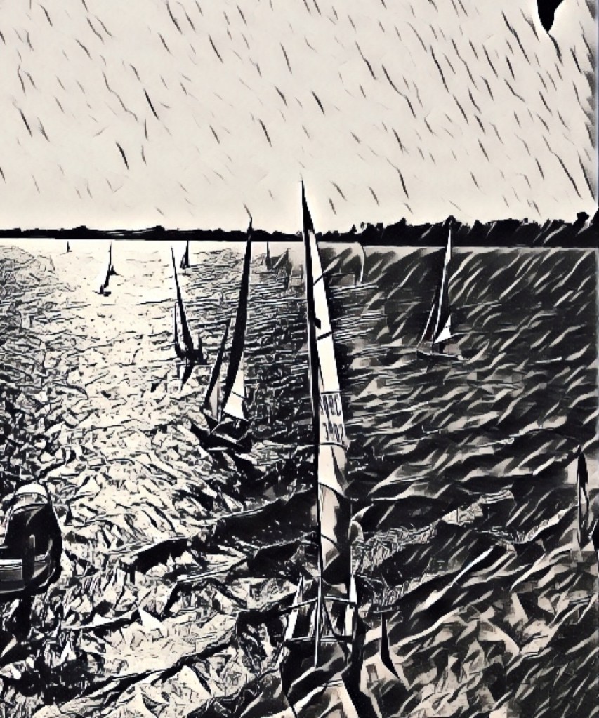
THE RESURRECTION OF LAKE CARGELLIGO. It had been dry for awhile. This video was taken on fifth of February 2010 as rains started to fall.
by:
Edgar T. Vagg

Eddie's editing take.

I watch a scene on the screen.

A resurrection of a lake.

On the third month it rose again from the dead.

The camera zoomed in on the distant shoreline.

I'm taken aback with the flood of emotion at the flood of water and its motion. Taken back to my childhood playground. Oh! Wading summers, willow summers, white-capped waves wash over wallowing wags. Whooping and wailing.

Yesteryear as sharp as the smell of weed and water and waders, pardalot and coots and water rat under willow roots.

Show me more for my memory store.

The camera zooms the placid waters.

Rowing and bailing, becalmed.

Sailing and bailing, gibeing and leaning and reaching in a choppy southwester. Shocked by the cool wet spray on a scorching summer's day.

Now shocked by the power of emotion.

An old friend has risen from the dead. Resurrected by moisture from the distant ocean.

Lake Cargelligo
Lake Cargelligo risen from the dead on the 15th February 2010
Cattle drive in the fifties from Bourke to Lake Cargelligo.
Related by Tom Holmes to Eddie Vagg on 2nd August 2011.
Dalgetys alerted Dave Cleaver to a big mob of cattle at Bourke.
Dave, Matt Hooker, Tom Meadows, Eddie Meadows decided that they would drive them back to the Lake and split them up when they got back.
Tom Holmes had cut his leg badly getting fence posts with his grandfather Tom Meadows.
Tom was on light duties so was seconded as a member of the droving team along with Des Vagg both still youngsters. Tom was 19 Des about 20.
Des had been a member of Daves shearing team.
They were given a mob of horses for the run. Tom Holmes picked out a little quiet white pony, no saddle.
There was a good looking horse that hadn’t been ridden and old Tom Meadows said it needed a breaker.
“Give me a saddle and I will ride it”, said Des. Bucked like hell but he stayed with it. Gave the saddle back and rode it bareback for the rest of the trip.
Matt Hooker had an old truck as the chuck waggon .
There were horse and carts and Eddie Meadows had a cut down car for a ute which wife Fay would run as a messenger vehicle to get supplies when needed.
She had Glenda and I imagine Carmel with her as they were only todlers.
A huge camp oven was constanly full of stew made from sheep sometimes beef as deals were made with passing stations.
Ollie Germine from Twin Wells between Cobar and Mount Hope was one noted station owner.
The camp oven was kept on Matt Hookers truck with a weight of something like a sugar bag on it to stop it from spilling.
Reheated over the campfire at tucker time. Pumpkins whole would be put in the camp oven after seeds removed.
They would kill and salt meat. Old Tom had a cool safe for fresh meat. They did the trip in winter/ spring weather, cooler, sometimes wet. Made old Toms damper making difficult.
Lots of yarns round campfire. Old Tom was as a bullock driver. He once was called on during the floods to get 90 bales of wool out of Merrigal and bring them 40k to the rail head a Lake Cargelligo. the trucks couldn’t get in.
Old Tom would ride back miles to an emu nest to collect eggs to make omlets. The old hen would keep laying.
The cattle were corralled at night with ringlock . They were a quiet mob of mixed breeds.
Old Tom rounded up a killer himself when he got to Cowan Downs. He used to work there dam sinking with his bullocks so felt entitled to one or two.
The station owners were welcoming so they did get to have a shower but it was mostly a dip in a dam.
The young fellows were paid five pounds a day. They were on the road for about 2 months. I remember brother Des coming home. He had a big black beard.
As the blacks and the greys with the Browns and the bays feed in the moonlight spell.
The eerie clink of the hobble chains
Comes clear on the crystal air.
As the cattle tramp out wide of the camp and stare at the fire there.
The peg-dogs Crouch as they watch and wait to keep the mob at bay
As an old dog lies with drowsy eyes and dreams of a distant day
And I dream too, of another night many years ago when a nervous mob with hearts athrob was pacing to and fro.
As I sat alone by the fire-side watching the moon appear
An owl swept by with a piercing cry and the cattle swung off in fear.
As I call to my mates and spring for my horse I saw the first fence fall as the frenzied feet of the cattle beat. No hope of stopping all
The air soon filled with a thundering roar of hoves on the powdering ground.
And the boss cried out “it’s a desperate ride but we’ve got to turn them around”.
We caught them up in the timbers edge after following them through the trees. I tighten my grip on reins and whip and press closer with my knees.
Their heaving backs like ocean waves rolled in the moonlight glow as the weak were spent they fell and went under the hooves below.
The boss and Mike, farther on than me, were swinging on to lead,
when I heard a scream, and the living stream flowed over one fallen steed.
The boss stopped his horse and rushed to Mike and lifted the trampled head. Then called to me.” Dont stop to see. I fear mike is dead.”
We chase them down to the treeless plain.
As whips rang out in command. As they jostled and bawled and stumbled and sprawled then started again alarmed.
But we held them in as their longhorns clashed, as they staggered then swung about.
and they puffed and sighed and propped and shied. But we held them with whip and shout.
We buried Mike in the town next day, good stockman he had been but rather sly with a shifty eye. If you know just what I mean.
A week went by we were droving still one man and one horse less when a car drew up with two strangers spry, spruce in their city dress.
They asked for Mike and the boss replied that the man they sought was dead. “we wanted him for a murder grim”. the old man then said.
“You’re a week too late” the boss remarked for sentence has been passed. And the cattle trod with the wrath of God on a dreadful night that’s past.
There’s a homeless wind on the plain tonight and the ring of the drover’s bell and I hear as before The stampede roar the night that Michael Fell.
Jean Graham
This poem belongs to my daughter in law Lauren Vagg’s grandmother.
She was born on the Plains. Lived her early years at “Pine Park” Jerilderie
Published this poem in a collection with her Mother Elizabeth called Verse of the Riverina in 1975
She married a Thomas from Lake Cargelligo =. She has since deceased. She spent some time with my wife teaching her her poetry skills. She did this to help her with her brain damage. I was so impressed with this work “stampede” .
Delivering resilient water resources for all water users in the Belubula Valley.
A 20-year Macquarie-Castlereagh region-specific strategy to improve the security and certainty of our water resources.The department’s Water Group is investigating options aligned with the Lachlan Regional Water Strategy and the Macquarie-Castlereagh Regional Water Strategy. These 4 options include: (The department is working with WaterNSW and Central Tablelands Water on this project.)
a new pipeline between Lake Rowlands Dam and Carcoar Dam to transfer up to 2 gigalitres of water per year, capturing spills and boosting supply
raising the Lake Rowlands Dam wall to increase storage from 4.5 gigalitres to 8 gigalitres
building a new dam 2.5 kilometres downstream of Lake Rowlands
connecting the Belubula and Macquarie valleys through an interregional pipeline.
Note: New South Wales Water has lots of information on these projects. Initially they have presented the four options from the Belubula Project as drought proofing the Belubula. But the last option commencing “connecting” in both projects gives this notion away.
It looks like it’s mainly designed to bolster the Macquarie- Castlereagh Project
Can we justify. The means of existence. The unbalanced way we disregard all for our own ends. We can and we do despite the evidence to the contrary. We need six planets to sustain our way of life. Then it would still put each planet we invade out of tilter. Because we still haven’t realised the link with every facet of the universe we live in. The chain. The chain of unbroken systems that support all the elements of this amazing planet. The ancient tribes did!.
deep gouged out channels.
drained flood plains.
Bovine belted banks.
No thanks
We can’t deny extraction. That is part of the symbiosis of entities. Every entity relies on something for its existence. It’s the over extraction and destruction of a link that upsets the equilibrium.
I got a plan. The Bureau of Metrology got the wherewithal. Using their regularly updated soil moisture map of Australia. The soil carbon maps of Australia. The saltation studies. The rainfall records.
The northern indigenous tribes have the wherewithall : The reestablishment of native perennial pastures using fire.
My Plan A
The use of GPS collared cattle. The use of Drovers. Remove the fences mental and material.
The wilder beast herds of old in Africa followed the feed across the veldt. And still do.
The bison did the same across America. Their journey ended when they were ere slaughtered by the invaders to starve the Indians out of existence.
The Spanish Shepard’s for thousands of years drove their stock across Spain following the pastures and still do.
Graziers of the Riverina moved their stock to the summer pastures of the high country of the Southern alps. Until they proved a danger to precious bogs.
Kidman the Pastoralist had his properties from northern to southern Australia to take advantage of Northern Rains of summer and the southern rains of winter.
We with modern technology could have our herds follow the feed.
The square paddock mentality for cropping and grazing brought to this great Southland from European conditions. Conditions that even European farmers are finding are destructive. It has to change. Cell grazing would work close to major centres where compost is available to regenerate tired soils.
Saltation of our land and water was held in check by our First Nation people knowingly or unknowingly by the way they used the land and its waters
Our settlers knowingly or unknowingly have left a timebomb . That time bomb was salination. Salt was ubiquitous in the Australian environment. It resides in our marine origin sedimentary rocks and saline ground water. Tree cover. perennial grasses and native farmers kept the system in this variable climate in sync .
It’s not to late to On riverside, log jams and overflows on floodplains maintained wet marshy swamps and billabongs*. This environment kept salt from surfacing. The soggy flood plains refreshed our fresh water streams and aquifers . They remained seeping and weeping through droughts. The rivers scour now freed of log jams. Just a channel for water orders to arrive on time. Bowmaster
A huge study of salt in the environment has been undertaken since European settlement. Today we have the bad news from minister of environment and heritage that this time bomb like land mines is being triggered by our land use and we have to change the way we do things.
While southern Australia shows little shift towards wetter or drier conditions for Autumn 2019 the past two to three decades have seen a decline in autumn rainfall. For example, from 1990, 24 of the 29 years have brought below average rainfall to southeast Australia (below the 1961-1990 average).
In addition to the natural drivers such as the El Niño–Southern Oscillation and the Indian Ocean Dipole, Australian climate patterns are being influenced by the long-term increasing trend in global air and ocean temperatures. SAM a system in the southern ocean is moving our southern fronts further south.
*Peter Andrews (rebuilding wet floodplains)
I can see the answer to disillusionment.
But i dont want to put my finger on it. It feels as if it would alienate me. Isolate me from where i am or imagine i am in my community.
I see the problem and the answer as divisive.
(Excuse me there is a willy wagtail knocking on my window). Oh he’s just picking last nights trapped insects off
the window. One of these days i will learn to communicate with them. (Love their energy.)
I suppose that is my view of the world as a human. Nothing in the cosmos is alien to me. Every thing is a link in the chain. Broken disillusioned people are broken links.
Trauma
I don’t expect any of us from the environment we call lake Cargelligo have anything to do with the trauma that was inflicted on the first people after the first fleet arrived. It’s the present day traumas that are perpetrated. These are the ones we are responsible for, as a people’s . As people’s, we can do something about. Do something about the traumas here and now. If we don’t then we are as guilty as our forebears.The traumas that exist in this community have their roots in natural ecosystems that Lake Cargelligo is so blessed with. Human beings need the natural environment to maintain equilibrium. Every thread of existence every thread of this web every ounce of our being depends on this web.
There’s other ways to pull away from a depressive road. At present too many are falling, crushed by the pressure to conform. Conform is the norm when it comes to violence. It’s normal to bash your partner to be big amongst your mates. Crowing to them that she gets what she deserves. Nailing the perpetrators. Is hard. Jailing the perpetrators is harder. Community unity to change the culture. Destroy the vulture who preys on our mind. We can all write. Express yourself. Honestly write what is depressing you. Write what’s makes you happy. We can put all these community stories together. Put them together on stage in the old theatre to expose our lack of understanding as a community
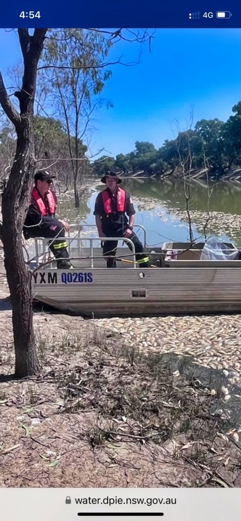
Sunset after the flood 2/3/2023. Environmental water flowing past My home on 703 River Road lake Cargelligo to protect the lower Lachlan from the sudden
dry
Galari ( Lachlan River)
It is the basis of my book Cargelligowetlands(see LachlanRiverlung.com) this Lachlan River in Central Western New South Wales . The large piece of prose in the book “Bastardisation of a magical river” looks at it from Oxley’s Diary angle and my angle expounding it’s flatness. It’s flatness are unique feature of a river that runs over most of its length.
Bastardisation of a magical river revisited
We didn’t realise it’s magical ability to store water through its whole length.
Bastardisation by coloniser Creations for convenience.
Made from shortsighted civilisations Returning negative results to our precious environment.
This essay:
I’m using Oxley’s journal of his journey down the Lachlan in 1817 to find out the true nature of this once pristine unique River System.
I’m using this approach to show where we have gone wrong.
This maybe an aid in embracing some of the rights and fixing some of the wrongs.
My comment: The following paragraph is the description by Oxley on his arrival on the Bathurst plains in 1817. Perfect example of how early settlers overran the excellent food resources maintained in a sustainable way for millions of years by the aboriginals at the very top of the western catchments.
Journal 14th April:: Bathurst had assumed a very different appearance since I first visited it in
the suite of his excellency the Governor in 1815. The industrious hand of man had been busy in improving the beautiful works of nature; a good substantial house for the superintendant had been erected, the government grounds fenced
in, and the stack-yards showed that the abundant produce
of the last harvest had repaid the labour bestowed on its culture. The fine healthy appearance of the flocks and herds was a convincing proof
how admirably adapted these extensive downs and thinly wooded hills are for grazing, more particularly of sheep. The mind dwelt with pleasure on the idea that at no very distant period these secluded plains would be
covered with flocks bearing the richest fleeces, and contribute in no small degree to the prosperity of the eastern settlements.
My comment: Aborigines. There hunting ground decimated for the woollen mills of Britain
My comment: The following paragraph of Oxley’s journey gives an example fire control the aboriginals of the Lachlan tribes practised. The other items mentioned is the drainage by limestone to take water under ground into the aquifer. The beginning of what I’m trying to explain about water the whole length of the system being stored
Journal 23rd of April: The timber standing at wide intervals, without any brush or undergrowth, gave the country a fine park-like appearance. I never saw a
country better adapted for the grazing of all kinds of stock than that we passed over this day. The limestone, which is the first that has hitherto
been discovered in Australia, abounds in the yy where we halted; the sides and abrupt projections of the hills being composed entirely of it, and worn
by the operation of time into a thousand whimsical shapes and forms.
A small stream runs through the valley, which in June 1815 was dry; the bottom of this rivulet was covered with a variety of stones, but the bases of the hills which projected into it, and from which the earth had been washed, were of pure limestone of a bluish grey colour.
My comment: Limestone country. Waterhole 14 miles from the Lachlan and no more water till the river. Must’ve gone into groundwater
My comment: Oxleys description On his arrival at the head of the Lachlan.
Journal 25th of April: At two o’clock saw the river, which certainly did not disappoint me: it was
evidently much higher than usual, running a strong stream; the banks very steep, but not so as to render the water inaccessible: the land on each side quite flat, and thinly clothed with small trees; the soil a rich light loam:
higher points occasionally projected on the river, and on those the soil was by no means so good. The largest trees were growing immediately at the water’s
edge on both sides, and from their position formed an arch over the river, obscuring it from observation, although it was from thirty to forty
yards across. At four o’clock we arrived at the depot.
My Comment: 25th April Oxley’s first sight of the Lachlan {and just short of their starting depot just beyond Cowra} in its high reaches, good description obvious floodplain and river banks and streamflow
My comment: The following paragraph gives the position of the depot where they begin the journey down the Lachlan . It was near Cowra the foothills of the catchment. 150m above sea level. Booligal near the other end of the catchment is 90m above Sea level. The unique gentle slope and geology mimics the flows of the Lachlan. This reasonably gentle slope enables storage for some time of water in swamps and groundwater for the whole length
Journal 27th of April: The observations which were made here placed the depot in lat. 33. 40.
S., and in long. 148. 21. E., the variation of the needle being 7. 47 E. The barometrical observations, which had been regularly taken from Sydney to this place, did not give us an elevation of more than six hundred feet above the level of the sea; a circumstance which, considering our distance from the west coast, surprised me much
My comment: The following paragraph highlights my proposition. There was plenty of harbour for Fish. Plenty of logs for slowing down the flow. Large shallow lagoon suggests shallow groundwater and there was plenty of birdlife in a stable ecosystem
Journal 29th of April: At six o’clock the boats arrived safe, the men having had a very fatiguing
row, and been obliged to clear the passage of fallen trees, and other obstructions; so that we determined to give them some repose, and halt
here for the night. At half past eight o’clock proceeded down the river, intending to stop at the termination of Mr. Evans’s journey in 1815, about
five miles further, for the purpose of repairing the small boat, which had sustained some slight damage in coming down the river yesterday. I rode
about three miles back into the country; the cupressus was here more frequent, though not of large growth; the soil is not good. In returning to the river we came upon the creek which terminated Mr. Evans’s journey,
down which we travelled until we came to the river, about half a mile from which is a large shallow lagoon, full of ducks, bustards, black swans, and
red-bills. At twelve o’clock the horses arrived at the mouth of the creek, and the boats half an hour afterwards. The banks of the creek were very
steep, and it was three o’clock before all the provisions were got over. The creek was named Byrne’s Creek,(Belubula River )after one of the present party, who had accompanied Mr. Evans in his former journey
My comment: The following sentence was made in the journal a day or so further on from Belubula confluence. Showing more proof of groundwater.
Journal Second of May: Upon the swamps were numerous swans and other wild fowl. In the evening we caught nearly a hundred weight of fine fish.
My comment: The following paragraph reinforces Oxleys opinion of area of the inundation just west of Jemalong gap which is now an irrigation district.
It uses the weir there to divert water into a channel system (Jemalong Irrigation scheme)
My comment: (And Oxley commented on this.)This area around Jemalong seems wet all the time. It stays in the Lanscape which means the groundwaters was saturated the whole length of the river system..
My comment: Google Earth over this area such as the Lachlan catchment shows by way of grey colour the extent of waterholes and marshes that existed beyond the river channel on the flood plain.
Journal sixth of May: I have reason to believe that the whole of the extensive tract named
Princess Charlotte’s Crescent (south of Jemalong gap) -is at times drowned by the overflowing of the
river; the marks of flood were observed in every direction, and the waters in the marshes and lagoons were all traced as being derived from the river.
Journal: During a course of upwards of seventy miles not a single running stream emptied itself into the river on either side; and I am forced to conclude that
in common seasons this whole tract is extremely badly watered, and that it derives its principal if not only supply from the river within the bounding ranges of Princess Charlotte’sCrescent. There are doubtless many small
eminences which might afford a retreat from the inundations, but those which were observed by us were too trifling and distant from each other to stand out distinct from the vast level surface which the crescent presents to the view.
The soil of the country we passed over was a poor and cold clay;
but there are many rich levels which, could they be drained and defended from the inundations of the river, would amply repay the cultivation. These
flats are certainly not adapted for cattle; the grass is too swampy, and the bushes, swamps, and lagoons, are too thickly intermingled with the better portions to render it either a safe or desirable grazing country
My comment: This Mount Cunningham mentioned in the next paragraph is this small Hill with the huge statue of an aboriginal warrior and is today on the River Road to Forbes. Oxley’s view on description paints a very wet scene. With the river overflowing its banks to fill up low-lying swamps indicating groundwater. This was a dry year in these parts. These flood pulses witnessed on his journey would have all come from winter fronts in the catchment. All the way to Goulburn
Journal 11th of May: At twelve o’clock ascended the south end of Mount Cunningham, a small branch of the river running close under it. From this elevation our view was very extensive in every direction, particularly in the western quarter. The whole country in that direction was so low, that it might not improperly be termed a swamp, the spaces which were bare of trees
being more constantly under water than those where they grew
My comment: This area west of Jemalong again explains how saturated the system was even in the dry season. The system is storing water in the ground water and slowly percolated forward downstream.
Navigation by river and land it’s so bad Oxley abandon the idea and headed for the coast at Cape Northumberland
Journal 12th of May: The river here became no longer navigable for boats. In pursuance of this intention we descended the hill, which was named
Farewell Hill, from its being the termination of our journey in a north-west direction at least for the present,
My present intention is to take a south-west direction for Cape Northumberland, since should any river be formed from those marshes,
which is extremely probable, and fall into the sea between Spencer’s Gulf and Cape Otway, this course will intersect it, and no river or stream can arise from these swamps without being discovered. The body of water now running in both the principal branches is very considerable, fully sufficient to have constituted a river of magnitude, if it had constantly maintained such a supply of water, and had not become separated into branches, and lost among the immense marshes of this desolate and barren country, which seems here to form a vast concavity to receive them. It is impossible to arrive at any certain opinion as to what finally becomes of these waters, but I think it probable, from the appearance of the country, and its being nearly on a level with the sea, that they are partly absorbed by the soil, and the remainder lost by evaporation.
My comment: Uniqueness of the Lachlan River is this realatively gentle slope giving it the ability to absorb and maintain lots of water both surface and ground water which is supposed to be intertwined. Extractions have destroyed the balance this once pristine System
I have since researched articles on Library of New South Wales site on salinity. Here’s a small extract to show what drying up marshes is capable of doing was far of salt loads go.”The combination of old weathered and relatively flat land surfaces, poorly drained soils and a variable and often dry climate has resulted in significant accumulation of salt in the Australian landscape.”
from
this extract was from an article on Hydrogeological Landscapes framework: a biophysical approach to landscape characterisation and salinity hazard assessment
Oxley gave up going to the coast at where Griffith is now . Headed north and was impressed when finding the river again. by then the river had got back into healthy stream. He hits the river near present Ballyroggan.
Journal June 22: After going eight miles and a quarter, we suddenly came upon the banks243
of the river; I call it the river, for it could certainly be no other than the Lachlan, which we had quitted nearly five weeks before. Our astonishment was extreme, since it was an incident little expected by any one. It was
here extremely diminished in size, but was still nearly equal in magnitude to the south-west branch which we last quitted. The banks were about
twelve or fourteen feet above the water, and it was running with a tolerably brisk stream to the westward.
My comment: Previous paragraph and the next Is worth reading. His summing up of lack of input from streams along the way. And still catching fish near Ballyroggan
Dryanders head is Mount Daylight
Journal 23rd June: .
It is a singular phenomenon in the history of this river, that, in a course of upwards of two hundred and fifty miles, in a direct line from where Mr.
Evans first discovered it, not the smallest rivulet, or, in fact, water of any description, falls into it from either the north or south; with the exception of the two small occasional streams near the depot, which flow from the north.( further up from where they started there is the Boorowa, Crookwell, Abercrombie rivers)
The country to the southward, in its soil and productions, explains pretty satisfactorily why no constant running streams can have sources in that direction; and it may be esteemed, as to useful purposes, a desert, uninhabitable country. A small strip along the sea-coast may possibly be
better, and derive water from the low hills which are known to border on it: south of the parallel of 34. S. may therefore be considered as falling under
the above designation and description of country.
The plains south of the river, and lying from Goulburn’s Range (Ural Range) to Macquarie’s Range (Lachlan Range)
, were named Strangford Plains; and a remarkable peak south of Barrow’s Hill, Dryander’s Head (Mount Daylight)
Journal 24th of June: It was a matter of considerable curiosity and interest to us, in what
direction the Macquarie River had run; it was clear that it had not joined
the present stream, for in that case it would have been much more considerable: we were within three or four miles of the latitude of Bathurst,
and it was scarcely probable that it should continue for so long a course to run parallel to the Lachlan. The whole form, character, and composition of
this part of the country is so extremely singular, that a conjecture on the subject is hardly hazarded before it is overturned; every thing seems to run counter to the ordinary course of nature in other countries.( The Lachlan has unique features is flatness and singularity of sauce.)
June 24.—The water is about three feet above the common level, and although the banks on both sides are certainly occasionally overflowed, there is no appearance of any fresh or flood having swollen the stream for a considerable time.
My comment: Wet wet wet the whole length even in the dry. Says something for ground water storage as opposed to dams and weirs.
Jews in Israel are of the same opinion in the following article.
Water Management in Israel
Key Innovations and Lessons Learned for Water-Scarce Countries (Short extract on ground water storage from the complete works)
Please cite the work as follows: Marin, Philippe, Shimon Tal, Joshua Yeres, and Klas Ringskog. 2017. Water Management in Israel: Key Innovations and
Lessons Learned for Fourth Innovation: Using Aquifers as Reservoirs
The first integrated supply scheme based on the national water system operated by Mekorot since the 1960s relied on the storage capacity of the Sea of Galilee and the Coastal and Western Mountain aquifers. Mekorot has added major infrastructure since then to connect and rationalize the operation of aquifers.
One of the most remarkable innovations of Israel water management is that aqui- fers have been gradually switched from being overexploited resources to becoming major storage reservoirs. The existence of the National Water Carrier and the large-scale use of seawater desalination and reclaimed wastewater an alternative nonconventional water sources made this possible.
The interconnected nature of the National Water Carrier affords the opportunity to optimize the operations of regional water schemes through over-pumping from local aquifers in dry years or artificial recharges in wetter years. The aquifers therefore serve as swing suppliers (i.e., buffers) while also minimizing evaporation losses that would have occurred had this water been stored in open reservoirs.
The hydraulic advantages of this integrated scheme are obvious in terms of higher reliability
My comment: He mentions water holes that look like they’ve been dry for a time and then in the same place 11 miles down a large lagoon partly full of water{shallow groundwater}
Journal 25th of June: At nine o’clock we set forward down the river; our course lay westerly,
and by three o’clock we had gone nearly twelve miles in that direction; when we stopped for the night on the banks of the river near the termination of Macquarie’s Range {Lachlan Range}, the north point of which I named Mount
Porteous.{Bakers Hill}
My comment: Mount Porteous now Baker’s Hill just over from Mountain Creek shearing shed Hillston Road.
Journal 26th of June: Perhaps there is no river, the history of which is known, that presents so
remarkable a termination as the present: its course in a straight line from its source to its termination exceeds five hundred miles, and including its windings, it may fairly be calculated to run at least twelve hundred miles;
during all which passage, through such a vast extent of country, it does not receive a single stream in addition to what it derives from its sources in the eastern mountains.
I think it a probable conjecture that this river is the channel by which all
the waters rising in those ranges of hills to the westward of Port Jackson, known by the name of the Blue Mountains, and which do not fall into the
sea on the east coast, are conveyed to these immense inland marshes; its sinuous course causing it to overflow its banks on a much higher level than
the present, and in consequence, forming those low wet levels which are in the very neighbourhood of the government depot. Its length of course is, in my opinion, the principal cause of our finding any thing like a stream for the last one
hundred miles, as the immense body of water which must undoubtedly be at times collected in such a river must find a vent somewhere, but being spent during so long a course without any accession, the only wonder is, that even those waters should cause a current at so great a distance from their source; everything however indicates, as before often observed, that in dry seasons the channel of the river is empty, or forms only a chain of ponds. It appears to have been a considerable length of time since the banks were overflowed, certainly not for the last year; and I think it probable they are not often so: the quantity of water must indeed be immense, and of long accumulation, in the upper marshes, before the whole of this vast country can be under water.
My comment: Oxley’s ponderings own the witness of the whole system. He’s making these assertions near Hillston before he decided to head back up river.256
The river had become just marshes and lakes. His observations here further cemented my opinion that this body of water from the source to the marshes stores more water then any weir or dam could ever do.
And it does it with a balance which makes inhabitants healthy the whole length of the system. That is all the environmental aspects be a healthy system, catchment Cover, flood plane Cover, ground water, Storage Fish habitat.
My comment:
from an article from Hydrogeological Landscapes framework: a biophysical approach to
landscape characterisation and salinity hazard assessment Salinisation of land and rivers is a major environmental problem affecting
many of Australia’s agricultural and urban areas. It has been estimated that land with a high salinity hazard and/or shallow water tables will increase nationally from approximately 5.7 million to 17 million hectares by 2050 (National Land and Water Resources Audit (NLWRA) 2001
Salt is mobilised in the landscape by the movement of water through the regolith and fractured rock. Water brings salt to the land surface and introduces salts to streams and rivers. Any factors that alter hydrology affect the deposition of salt, the partitioning of salt and the mobilisation of salt. These factors include changes in vegetation cover, land use, water extraction and most human land developments (Walker et al. 1999).
My comment:
He ended his journey Down Lachlan turned around and headed back somewhere near Booligal
Journal: July 9.—The morning fair and pleasant, but cold, the ground being covered with hoar-frost. At half-past eight we set out on our return eastward, every one feeling no little pleasure at quitting a region which had presented nothing to his exertions but disappointment and desolation.
Under a tree near the tent, inscribed with the words “Dig under,” we buried a bottle, containing a paper bearing the date of our arrival and departure, with our purposed course, and the names of each individual that composed the party.
My comment:This paragraph commencing with June 11 heading somewhere near Ballyroggan the river was almost dry now become a rolling agitated muddy water near level with the bank,
Puzzling overnight rise. Many swampy areas and lakes. Having to keep close to the river near my home at 703River Road to avoid the marshes and lakes to the south. North of the north Uabba road
Eddie
Journal: July 11.—At nine, again set forward on our return up the river, and it was near four o’clock before we arrived at a convenient halting-place on its
banks; the river presented a most singular phenomenon to our astonished view. That river which yesterday was so shallow that it could be walked across, and whose stream was scarcely perceptible, was now rolling along its agitated and muddy waters nearly on a level with the banks: whence this sudden rise, we could not divine, any more than we could account for the non-appearance of a fresh twenty miles lower down; unless the marshes which we have traced for the two last days, at a distance from the river, should have absorbed the waters in passing, or unless the extremely winding course should so protract and retard the current of them as to cause a considerable time to elapse before a flood in the upper parts could reach the lower. We considered ourselves as extremely fortunate
My comment: He was making his way what used to be Smalls Lake and Lake Creek on Weir road Where he built the bridge to get through up river towards Kiacatoo. Rode up onto the Common to Survey the area around Lake Cargelligo,
Goulburn Range is the present northey’s hills or Ural Range.
Discovered lake cargelligo. Further evidence of fire farming with cleared park like land around the western shores
eddie
Journal: July 23.—The river had fallen a little during the night. At nine o’clock we again set forward: the country became extremely low and marshy, far more
so than any we had passed over east of Macquarie’s Range. These marshes extended so far southerly that to have gone round them would have led us far from our purposed course without answering any useful purpose, and although we judged that at first they might not extend above three or four miles back, yet we soon had reason to change that opinion. The river had led us upon a general course nearly east about six miles, when about half a mile from the bank southerly, a very extensive lake was formed, extending about east-south-east and west-north-west from three to four miles, and being about a mile and a half wide. Excepting the sheet of water on the north side near the termination of the stream, this was the only one we had seen that could justly be entitled to the denomination of lake. We crossed over a low wet swamp, by which its overflowings are doubtless reconveyed to the river. This lake was joined to another more easterly, but
much smaller. We could not form any correct judgment how far the marshy ground extended south-east of it; but the country was low and level as far
as Mount Byng [ Sansons Hill}, and a low range extended north-easterly from it.
We now
kept the banks of the stream, till at the tenth mile we ascended a small hill a mile south of it, from which Mount Byng bore N. 12. E. Close under the hill ran a considerable branch of the river, which certainly supplied the lakes and lower grounds with water; on the other side of this arm, the country was low, and apparently marshy as far as we could see. On examination I found it would be extremely difficult to cross this branch, as the water was too shallow to swim the horses over, and the ground so soft that they could not approach the banks within several yards. I therefore
determined to get upon the river nearly where this branch separated from it, and endeavour to construct a bridge, by which we might convey the provisions and baggage over: as to the horses, they could easily swim across.
Our bridge was finished by one o’clock, but it being too late to cross the horses and baggage this evening, I went in company with Byrne on horseback to view the country to the southward. After going about two miles and a quarter south of the tent, we were most agreeably surprised with the sight of a very fine lake; we rode down to its shores, which on this side were hard and sandy beaches. On the south side the shores were bolder, being red clay cliffs. We now found that the creek or arm which I
had supposed to be the source whence Campbell {Smalls} Lake was supplied, had
not any communication with it, but supplied the lake we now saw: a low ridge of hills, bare of trees except small cypresses in clumps, lying between the two lakes, which were distant from each other two or three miles.
Finding I might obtain a better view by going to the point of these bare hills about five miles westward, I rode thither along the margin of the lake, but quitted it to ascend the hill, which was about two miles and a half from
it. The hill was but low in comparison with Goulburn’s{Urals} Range and other hills in the vicinity, but was sufficiently elevated to afford me the most
varied and noble prospect I had seen in New South Wales. The expanse of water was too large and winding to be seen in one point of view, but it broke in large sheets from east to west for upwards of six miles; its medium breadth being from two and a half to three miles: it was bounded six or seven miles from its eastern extremity by a low range of hills
connected with Mount Byng,{Sansons Hill} and from the dark broken woody appearance
of the country in that direction, I felt assured that the stream came from a more northerly quarter. To the westward was Goulburn’s{Urals} Range, distant about five or six miles; its bold rocky peaks of lofty elevation forming a striking contrast to the dead level of the country southerly, in which
however Mount Acton appeared like a blue speck on the horizon. To the northward was Mount Granard, the highest of a very elevated range, it having been seen at a distance of seventy-two miles from Mount Acton; and to the north-north-east were extensive open flats; in one place, bearing
N. 17. E., I thought I could distinguish water. Between the hill on which I stood and the stream, Campbell{Smalls} Lake wound along the plain, but its
width
did not allow it to be so conspicuously seen as the present one. To the south-east and round to the north-east the country was covered with dark
foliage of the eucalyptus, intermixed with the cypress; whilst to the southwest, as far as the base of Goulburn’s{Urals} Range, it was more open, with gentle hills clothed with a few small cypresses. These hills were rocky and barren, the lower grounds a red loamy clay; but the intermingled light and shade formed by the different description of trees and shrubs, the hills, but above all, the noble lake before me, gave a character to the scenery highly picturesque and pleasing. [Oxley named this lake Regents Lake now Lake Cargelligo]
My comment: The Lake mentioned in the next paragraph is sheet of water
Journal:July 26 After proceeding to the north-east about three miles, through a low, wet,
and barren country, which is at times from eighteen inches to two feet under water, we came upon another fine lake about a mile distant from the river. This lake was not so large as the last, but was nevertheless a fine sheet of water, about three miles long and one and a half or two miles wide; the opposite or south shore was much more elevated than that near the river, which had here extremely low banks, the water in the stream not being above four feet below them; the marks of flood upon the trees were also upwards of three feet higher.
My comment:The following entry in his journal is One of the many indications of fire farming he came across on his journey but didn’t call it that
Journal: July 27 These plains were now dry and hard, and having been lately burnt, the coarse natural herbage springing up fresh, gave them a pleasing green appearance. One or two beautiful new shrubs in seed and
flower were found to-day, to the great satisfaction of the botanists, who had not lately made many very splendid or valuable additions to their collections.
A party of natives was seen on the opposite side of the river, consisting of one man, two lads, and two women; they disappeared as soon as they observed us.
My comment: more swamps lagoons and wildlife heading towards kiacatoo
Journal July 28: Of the swamps, which in places, extended from eight to ten miles from
the river south-east and south, some parts were dry and others under water; and there were occasionally large lagoons covered with innumerable wild fowl of various descriptions. Great numbers of native-companions, bustards, and emus, were seen on the plains, which, at the termination of our day’s journey, were of a better and drier description than usual
My Comment: Crossing the Lachlan near kiacatoo heading towards the Macquarie and Bathurst without going past marshy land at Jemalong where they detoured coming down
Journal 29th of July:It was determined that as we had now ascertained the course of the
Lachlan, from the depot to its termination, any farther trace of it, running as it did from the south-east, would take us materially out of our purposed course to Bathurst, without answering any good purpose, at the same time that we should entangle ourselves in the marshy grounds which had been seen both from Mount Cunningham,
My Comment: This next paragraph further highlights the wetness and the ability to obtain wetness the whole length of the system
Eddie Vagg
Journal August 2: Nothing can afford a stronger contrast than the two rivers, Lachlan and
Macquarie; different in their habit, their appearance, and the sources from which they derive their waters, but above all differing in the country bordering on them; the one constantly receiving great accession of water from four streams, and as liberally rendering fertile a great extent of country; whilst the other, from its source to its termination, is constantly diffusing and extenuating the waters it originally receives over low and barren deserts, creating only wet flats and uninhabitable morasses, and during its protracted and sinuous course is never indebted to a single tributary stream.
My Comment; I’m writing this in the middle of a major flood event in the Lachlan Valley. It has me further reflecting on what Has been told of
on a much more major system The Murrumbidgee.This Native told the early
inhabitants of Gundagai ‘getaway from the floodplain’. They took. no notice and a big flood washed the settlement away. This aboriginal in a bark canoe rescued some and took them to Highground
eddie vagg
Lachlan River. 703 River Road Lake Cargelligo NSW Australia after the floods of 23.
and the healing wounds of a Country under the weather
Chains and bladders and healing wounds of a country under the weather. This poem was written by me during the many ebbs and flows of the Lachlan River. This was a dry spell around 2009 that prompted me to write this way
The trees were chained to near extinction
.
The natives were chained to near submission
on the mission
on the river
life giver
.
The chain of ponds were unchained
.
Draining the ponding that was bonding the river health
and the natives hydraulic wealth. All removed by stealth
.
He was under the weather
.
One could knock him over with a feather
.
His spirit was broken. A token of a man
He sucked on the bladder. The death adder bladder
.
It was the demons breast at best. His life was heading west
.
Him, product of wounded country under the weather
.
Will the winds of change lance the festering wound
that is a blight today tomorrow and tonight?
The wound
Heel! we said to the terriers of terra nullas
.
Like a mungrel pup we shot those that played up
.
Took the children away in trains to train them
to see if we could control, mould them to our image
Heel. We said as we razed the bush.
Raised the flag of victory over a people who knew that no land is won or lost by war
.
The invaders feet have tangled in nets there and his blood is thinned by fears. ( judith wright)
Judy Wright you were right when you said ” no land is won or lost by wars. The invader feet will
tangle in nets there. And their blood be thinned by fears”
.
Plight comes with shooting and uprooting natives.
Blight casts over uprooters now falling under appalling pollution
.
Internal sores unknown cause
.
Polluted bores. saltier than the Asores. Where’s the solution
.
Straight shooters might say enoughs enough
.
But they live in fear of stepping up a gear
.
The status quo is hard to throw.
Step out of line and ” down ya go”
.
Well my back is arched
.
Arched as a tom cat confronting wild dogs.
My claws are sharp and ready to rip into the authorities by way of the poetic word.
Scratching them indelibly into the annals of time.
Their backstabbing, baseless and tasteless against the onslaught
.
You know the bush is parched. There are no sounds in the night, not a frog or a cricket or a
mopoke.
The summer heat and the bare ground, parched.
Take a stand.
Take A stand of trees and get them off their knees.
Start at the road strips.
Move the fences out into fallow
.
Metres at a time
.
The remnants will self propagate, regenerate.
A virtual fence is all that is needed.
The task is an ask,
a bitter pill,
a bit up hill.
We have to take the challenge and cure the ill.
The ill wind.
It will rescind,
the thread that binds,
the Cyprus pines
,
the stable minds
.
The ill wind defines,
the line in the sand
and the sand will expand out of hand,
the land unmanned. Deserted deserted.
The sun bakes the naked banks on the far canal
farken al farken al .
when will we learn
make a u turn
regenerate instead of decimate mate.
Weeping willows, weep no more.
Wind swept waters,
waders wander wonder,
what a coot
no water rat under willow root
barren banks eroded exposed.corroded.
Managing minds imposing fines
.
Menacing wands weaving black magic with glyphosate mate
cumbunji kaboom
.
No more do they deliver the filter for water as they orta.
No more are they haven for waterfowl
,
hunting area for the night owl
.
Bovine bellows fill the night noises
.
Cavorting and crunching they destroy the cumbunji .
Gee,m, your giving the natural state a use by date mate.
Shut the gate mate as you leave for the city.
Your self imposed 21st century penitentiary
Pity you couldn’t love the land like the ancient clan did.
Instead you sold her for a gready quid
.
Don’t deny it, yes you did.
From Eddie to anyone who wants to trade denial for truth telling.
Extracts from oxley’s diary as he passed through Lake cargelligo. Extracts from his observations made in Guttenberg Press publication of his daily diaries as he came down and up the Lachlan. in 1817.
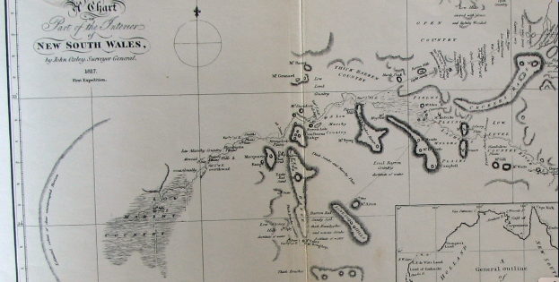
Oxleys map is a part sketch of the area bounded by the Northys Hills in the west and Sansons Hills in the east. The Lachlan River runs from the north-east to the west. Smalls Lake and Lake Cargelligo are circled in. Smalls Lake is Campbells Lake and Lake Cargelligo is Regents Lake. Northys Hills is the Goulburn Range. Mount Bing is Sansons Hills to the east of the Lachlan Range. Notice he has called all that area between “low marshy country”.
I’m posting this to reinforce the fact oh how depleted Lachlan Valley has become after colonisation.
Oxleys diary July 23, 1817 :
The river had fallen a little during the night. At nine o’clock we again set forward: the country became extremely low and marshy, far more so than any we had passed over east of Macquarie’s Range.(Lachlan) These marshes extended so far southerly that to have gone round them would have led us far from our purposed course without answering any useful purpose, and although we judged that at first they might not extend above three or four miles back, yet we soon had reason to change that opinion. The river had led us upon a general course nearly east about six miles, when about half a mile from the bank southerly, a very extensive lake was formed, extending about east-south-east and west-north-west from three to four miles, and being about a mile and a half wide. Excepting the sheet of water on the north side near the termination of the stream, this was the only one we had seen that could justly be entitled to the denomination of lake. We crossed over a low wet swamp, by which its overflowings are doubtless re-conveyed to the river. This lake was joined to another more easterly, but much smaller. We could not form any correct judgment how far the marshy ground extended south-east of it; but the country was low and level as far as Mount Byng, and a low range extended north-easterly from it. We now kept the banks of the stream, till at the tenth mile we ascended a small hill a mile south of it, from which Mount Byng(a hill somewhere between Lake Cargelligo and Tullibigeal) bore N. 12. E. Close under the hill ran a considerable branch of the river, which certainly supplied the lakes and lower grounds with water; on the other side of this arm, the country was low, and apparently marshy as far as we could see. On examination I found it would be extremely difficult to cross this branch, as the water was too shallow to swim the horses over, and the ground so soft that they could not approach the banks within several yards. I therefore determined to get upon the river nearly where this branch separated from it, and endeavour to construct a bridge, by which we might convey the provisions and baggage over: as to the horses, they could easily swim across.
The course of the river during the day had been nearly due east, but from the separation of the branch it seemed to take a more northerly direction; the banks were very low, and never exceeded five feet from the water. Occasional points of land somewhat more elevated than the general surface would of course make them in Places a little higher; but we could not discover any marks which denoted a greater rise than six feet, or six feet six inches, above the present level. When we halted in the evening, the stream was running with great rapidity. The water did not appear to have either risen or fallen during the day; but all the trees which would have best answered our purposes were now several feet in the water. We had however no alternative but to cross somewhere in this neighbourhood, as we were fearful of entangling ourselves in marshy ground by proceeding farther up this bank; and to attempt to penetrate, or even to round, the marshes to the southward, (if it were practicable,) would take up more time (without being of any service) than we could spare. Experience had made us too well acquainted with the nature of these marshes to run any needless risks; and we had besides great hopes that we should find better travelling to the northward, which as the river seemed inclined to come from that point would also be a great convenience to us, as I did not purpose to quit its banks as long as it continued to run any thing north of east.
As to the soil and general description of country passed over this day, the low-lands were all swamps covered with atriplex bushes, and where the land was a little more elevated, the soil was sandy and barren, covered with acacias, dodonaeae, small cypresses and dwarf box-trees. Our course was E. 4. N. 6¾ miles; but by the windings of the river, we had measured nearly 12 miles. The lake I named Campbell Lake (Smalls Lake), in honour of Mrs. Macquarie’s family name.
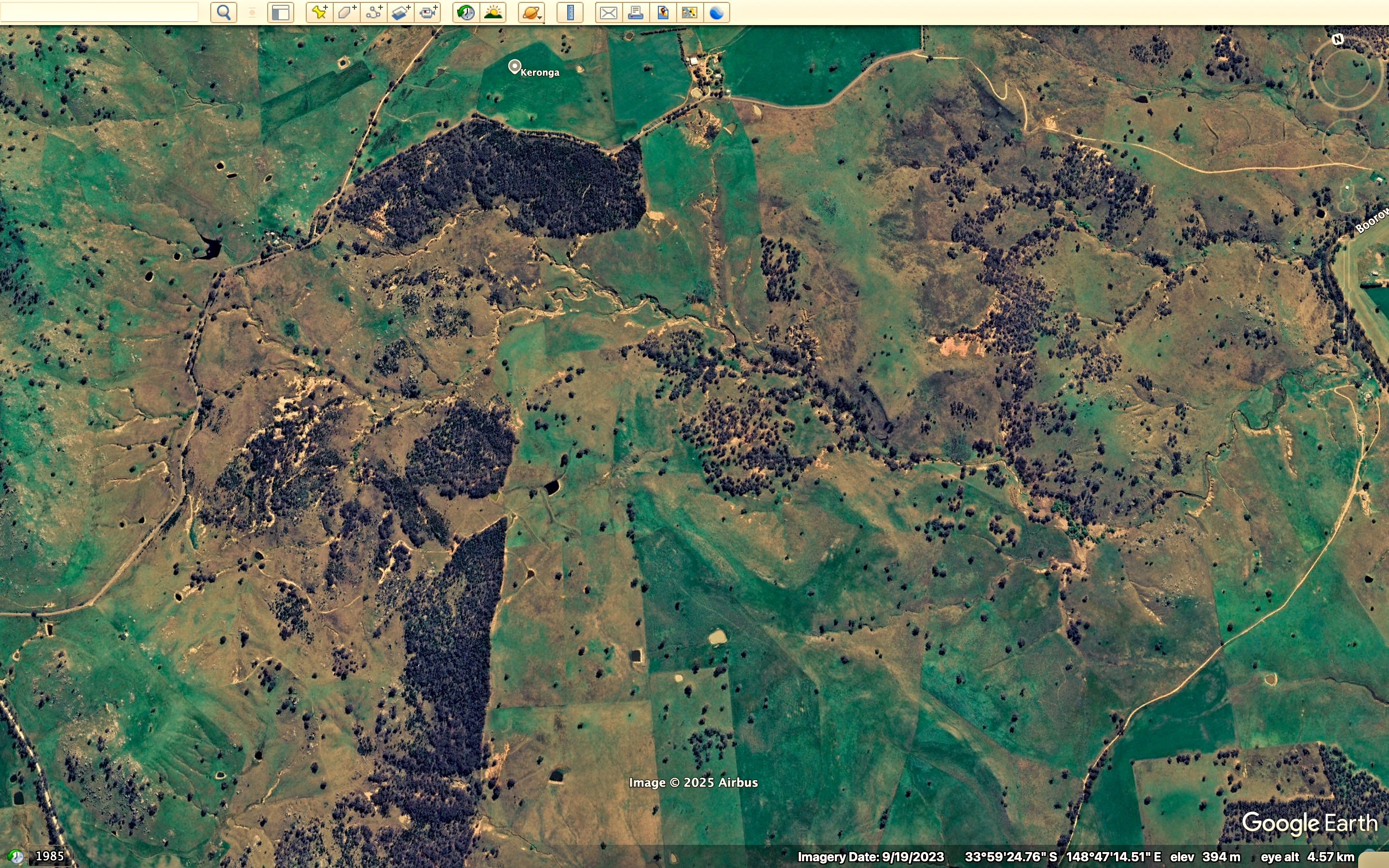
This Google Earth screenshot is the present day aerial view of the country Oxley is describing in his daily diaries of the 23rd and 24th of July 1817
July 24.—At day-light we attempted to construct our bridge near to the place where we were encamped, but as fast as the trees were felled they were swept away by the rapidity of the current; the breadth on an average being now, by reason of the flood, nearly sixty feet, and the trees on the immediate or proper banks being several feet in the water: we were therefore obliged to fell trees farther inland, and these, as before remarked, were swept away, falling short of the land on the opposite side.
All our attempts to construct a bridge during the day were fruitless, as the flood was too violent to allow the trees to take firm hold: in searching the banks of the stream for a proper place for our purpose, an arm nearly as large as the main branch up which we had travelled was discovered about a mile down the stream on the north side; it ran to the north-north-west, and then apparently trended more westerly. Thus is this vast body of water, all originating in the Eastern or Blue Mountains, conveyed over these extensive marshes, rendering uninhabitable a tract which they might reasonably be expected to fertilize.
Finding that in the present high state of the water we could not succeed in crossing the river, at least near our present station, and that if we returned lower down we should experience a farther difficulty in crossing the north-west arm recently seen, it was judged best to try if we could get over the branch on the south side, and swim the horses over in the main stream near the mouth of the branch. We could not, however, find any tree on this side that would reach across; although it was quite dark before we gave over the attempt for the night.
Oxley’s own map of his journey down the Lachlan 1817. The journey began at Cowra. He was blocked at Gemalong near Forbes on his way down. Was heading back to the sea in the south to hitch a ride back to Sydney. Turned around again near the present day Griffith went north to find Lachlan again. Proceeded down stream to Booligal then returned again past Lake Cargelligo. Crossed the river near Kiacatoo went back to the Macquarie and made his way back to Bathurst from there.
July 25.—Every means was again employed in constructing the bridge over the south-west branch. The stream had fallen but a few inches, and continues to fall too slowly to permit us to entertain any hopes of crossing it in this vicinity.
Our bridge was finished by one o’clock, but it being too late to cross the horses and baggage this evening, I went in company with Byrne on horseback to view the country to the southward. After going about two miles and a quarter south of the tent, we were most agreeably surprised with the sight of a very fine lake( Lake Cargelligo); we rode down to its shores, which on this side were hard and sandy beaches. On the south side the shores were bolder, being red clay cliffs. We now found that the creek or arm which I had supposed to be the source whence Campbell Lake( Smalls Lake) was supplied, had not any communication with it, but supplied the lake we now saw: a low ridge of hills, bare of trees except small cypresses in clumps, lying between the two lakes, which were distant from each other two or three miles. Finding I might obtain a better view by going to the point of these bare hills about five miles westward, I rode thither along the margin of the lake, but quitted it to ascend the hill, which was about two miles and a half from it. The hill was but low in comparison with Goulburn’s Range. Northeys HIlls) and other hills in the vicinity, but was sufficiently elevated to afford me the most varied and noble prospect I had seen in New South Wales The expanse of water was too large and winding to be seen in one point of view, but it broke in large sheets from east to west for upwards of six miles; its medium breadth being from two and a half to three miles: it was bounded six or seven miles from its eastern extremity by a low range of hills connected with Mount Byng (Sansons Hills), and from the dark broken woody appearance of the country in that direction, I felt assured that the stream came from a more northerly quarter. To the westward was Goulburn’s Range,(Northeys Hills) distant about five or six miles; its bold rocky peaks of lofty elevation forming a striking contrast to the dead level of the country southerly, in which however Mount Aiton(perhaps IllawongHills) appeared like a blue speck on the horizon. To the northward was Mount Granard, the highest of a very elevated range, it having been seen at a distance of seventy-two miles from Mount Aiton; and to the north-north-east were extensive open flats; in one place, bearing N. 17. E., I thought I could distinguish water. Between the hill on which I stood and the stream, Campbell Lake (Smalls Lake) wound along the plain, but its width did not allow it to be so conspicuously seen as the present one. To the south-east and round to the north-east the country was covered with dark foliage of the eucalyptus, intermixed with the cypress; whilst to the south-west, as far as the base of Goulburn’s Range (Northeys hills), it was more open, with gentle hills clothed with a few small cypresses. These hills were rocky and barren, the lower grounds a red loamy clay; but the intermingled light and shade formed by the different description of trees and shrubs, the hills, but above all, the noble lake before me, gave a character to the scenery highly picturesque and pleasing.
From this eminence I took the following bearings to objects connected in the survey, viz.The highest point of Goulburn’s Range N. 225 degrees distance 5 or 6
miles.
Do. Do. Mount Aiton 143
Table Hill 116
Mount Byng 114
West extreme of the lake N. 106. 30. distance 2½ miles.
East Do. Do. N. 65. distance 5 or 6 miles
Highest point of Mount Granard N. 341
Extremes of extensive flats from N. 346½ to N. 10. distance